
 Translate
Ecoregions
An ecological region, or ecoregion, is a large area of the landscape with distinctive groupings of plants and animals and their interactions. These plant and animal assemblages have evolved together over thousands of years. Their distinct climate, soils, elevation, landforms, and hydrology shaped their evolution. All these characteristics form ecosystems, which in turn help define the ecoregion.
Within a given ecoregion, relationships between species and their physical environment are similar. The ecological roles that species have in an ecoregion is roughly the same throughout that ecoregion, but roles may be different in a different ecoregion. One example of the different roles a species may play is found in our Pacific salmon. In the ocean, they are predators to smaller fish and prey to larger animals like orcas and sea lions. But when the salmon return to the streams of Puget Sound, they are functioning like a fertilizer as they bring all those ocean nutrients back with them and deposit them when they die after spawning. They are no longer predators at all -- they have stopped eating altogether. Their roles are very different in these different ecoregions.
The King County Biodiversity Report includes an extensive discussion on the ecoregions of the County. The information on this page is intended to complement and supplement the Biodiversity Report.
Ecoregions provide a useful framework to better understand, plan for, and conserve the marine, freshwater, and terrestrial environs of the county. Many organizations use ecoregions as a way of talking about animals or plants:
- BirdWeb has a directory to birding in the Ecoregions of Washington State.
- Landscope Washington has maps of ecoregions for all regions of Washington State.
- U.S. Forest Service discussion of Ecoregions, including links to other groups using ecoregions for ecological planning and management.
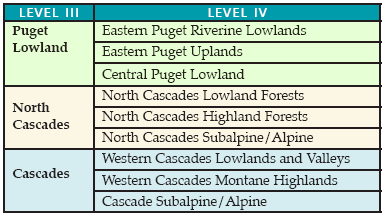
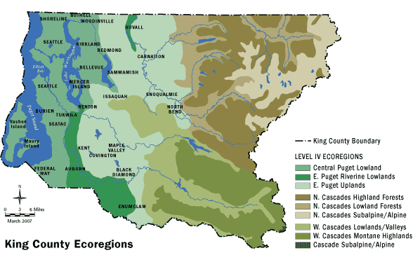
King County's ecoregions are based on U.S. Environmental Protection Agency (EPA) ecoregion conventions. EPA’s ecoregions have been mapped across North America and are classified into four levels, each with increasing complexity and detail. There are only 15 Level I ecoregions across the entire continent. King County falls within two of these: Marine West Coast Forests and Northwestern Forested Mountains. There are 52 Level II ecoregions. The two that occur across King County correspond identically with the Level I ecoregions: Marine West Coast Forest and Western Cordillera. Level III ecoregions describe smaller ecological areas nested within Level II regions. There are three Level III ecoregions in King County: Puget Lowlands, Cascades, and North Cascades. Level IV ecoregions describe an even finer scale of nested ecological areas. Level IV ecoregions identify locally defining characteristics and can be used to formulate specific management strategies for local conditions. In King County, there are nine Level IV Ecoregions. The table below provides more specific information for each of the Level IV Ecoregions found in King County.
|
Level IV Ecoregion and characterization |
Physiography |
Elevation (ft) |
Potential Natural Vegetation |
Land Use and Land Cover (current conditions) |
|
Puget Lowland |
||||
|
Eastern Puget Riverine Lowlands – composed of floodplains and terraces. Western redcedar forest, western hemlock forest, and both riverine and wetland habitat were common before the 19th Century. Subsequently, many of the wetlands were drained. Pastures, cropland, forests, and urban centers now dominate the landscape. |
Floodplains and terraces with meandering rivers, oxbow lakes, and meander scars. Freshwater and estuarine wetlands. |
0-800 |
Western redcedar, western hemlock; some red alder, black cottonwood, bigleaf maple, Sitka spruce. |
Crop and pastureland (e.g., reclaimed wetland); some riparian deciduous woodland, coniferous forests, wetlands; rural/residential/suburban/urban/ industrial activity. |
|
Eastern Puget Uplands – made up of rolling moraines and foothills and is a zone of transition. Both Puget Lowland and Cascadian vegetation associations occur with the latter most common in areas of greatest elevation and precipitation. |
Rolling moraines and foothills with lakes and sinuous streams and rivers. |
0-2677 |
Western hemlock western redcedar; some Douglas-fir. |
Douglas-fir/western hemlock forests. Forestry, pasture and cropland, rural residential/suburban/urban development. |
|
Central Puget Lowland – the heart of Puget Sound. Its undulating drift plains are heavily urbanized in the east and more rural and forested in the west. Well-drained, gravelly soils are common and exhibit limited moisture holding capacity and rather low agricultural productivity. |
Undulating glacial drift plains with lakes and small, sinuous streams. Coastline is irregularly shaped. It is characterized by many bays and some cliffs. |
0-1000 |
Western hemlock western redcedar; Douglas-fir; some red alder, bigleaf maple. |
Urban/suburban/industrial activity especially in east. Elsewhere, Douglas-fir/western hemlock forests, forestry, limited agriculture, rural residential development. |
|
Cascade |
||||
|
Western Cascades Lowlands and Valleys – characterized by a network of steep ridges and narrow valleys. Elevations are generally less than 3200 feet and are the lowest in the Cascades Ecoregion. The wet, mild climate promotes lush forests that are dominated by Douglas-fir and western hemlock. It is one of the most important timber producing areas in the Northwest. |
Westerly trending ridges and valleys with reservoirs and medium gradient rivers and streams. U-shaped, glaciated valleys in the east. |
800-4000 |
Western hemlock, western red cedar, Douglas-fir. |
Douglas-fir/western hemlock/western redcedar/vine maple/red alder forests are widespread. Forestry and recreation are important land uses and pastureland occurs in lower valleys |
|
Western Cascades Montane Highlands – composed of steep, glaciated mountains that have been dissected by high-gradient streams. It has lower temperatures than the Western Cascades Lowlands and Valleys and is characterized by a deep annual snow pack. Soils are of the frigid and cryic temperature regimes and support forests dominated by Pacific silver fir, western hemlock, mountain hemlock, Douglas-fir, and noble fir. |
Steep, glaciated, dissected mountains and ridges with high to medium gradient streams and glacial rock-basin lakes. |
2800-5900 |
Pacific silver fir, western hemlock, mountain hemlock, Douglas-fir; some noble fir. Snow-influenced. |
Extensive Pacific silver fir/western hemlock/Douglas-fir/mountain hemlock/noble fir/subalpine fir/grand fir/white fir forests. Common land uses include forestry and reacreation. Ecoregion is an important regional water source. |
|
Cascade Subalpine/Alpine – an area of high, glaciated, volcanic peaks that rise above subalpine meadows. Elevations range from 5600to 12000 feet. Active glaciation occurs on the highest volcanoes and decreases from north to south. The winters are very cold and the growing season is extremely short. Flora and fauna adapted to high elevations include herbaceous and shrubby alpine meadow vegetation and scattered patches of mountain hemlock, subalpine fir, and whitebark pine. |
High, glaciated, volcanic peaks with cascading streams, glacial cirques, and tarns. Active snowfields and glaciers more common to the north. Active and dormant volcanoes. |
5600-14410 |
Herbaceous and shrubby subalpine meadow vegetation; scattered mountain hemlock, subalpine fir stands. |
Bare rock, glaciers, subalpine meadows, and forests. Land uses include back-country recreation. Ecoregion is an important regional water source. |
|
North Cascade |
||||
|
North Cascades Lowland Forests – is composed of low mountains, broad glaciated valleys, and glacial-fed rivers that receive, on average, 60 to 90 inches of precipitation per year. Extensive, productive rainforests have developed under the mild maritime climate and are dominated by western hemlock, Douglas-fir, and western redcedar. Pastures occur in the valleys. |
Low mountains and broad, glaciated valleys with permanent, medium gradient, glacial-fed rivers and streams. Reservoirs and glacial lakes. |
400-3400 |
Western hemlock, western redcedar, Douglas-fir. |
Mainly western hemlock/Douglas-fir/ western redcedar forests. Forestry is the dominant land use; rural residential development, recreation, and valley grazing also occurs. A mix of publicly and privately owned lands. |
|
North Cascades Highland Forests – consists of steep, glaciated ridges, high-gradient streams, and tarns. Colder climatic conditions, deeper snow pack, and Pacific silver fir/mountain hemlock forests distinguish it from the North Cascades Lowland Forests. |
Steep, glaciated ridges; with permanent, cascading glacial streams and glacial rock-basin lakes. Some rock outcroppings. |
2800-6400 |
Pacific silver fir, mountain hemlock, western hemlock; some subalpine fir. |
Extensive forests composed primarily of Pacific silver fir and mountain hemlock. Common land uses include forestry and recreation. Most of the land is in public ownership. |
|
North Cascade Subalpine/Alpine – characterized by high mountain peaks, bare rock, glaciers, many tarns, plentiful precipitation, and sediment-laden glacial meltwater streams. Subalpine meadows occur around the taller peaks; their flora and fauna is adapted to the prevailing subarctic climate. |
High mountain peaks with bare rock, glaciers, cirques. Permanent, high gradient, sediment-laden, glacial meltwater streams and glacial rock-basin lakes. |
5500-10775 |
Herbaceous and shrub alpine meadow vegetation; some mountain hemlock, subalpine fir, subalpine larch. |
Alpine meadows, bare rock, glaciers, snowfields, some subalpine forests. Wilderness recreation is a common land use. Most of the land is publicly owned and is a regional water source. |
Omernik, J.M. 1987. Ecoregions of the conterminous United States. Map (scale 1:7,500,000). Annals of the Association of American Geographers 77(1):118-125.
Pater, D.E., S.A. Bryce, T.D. Thorson, J. Kagan, C. Chappell, J.M. Omernik, S.H. Azevedo, and A.J. Woods. 1998. Ecoregions of Western Washington and Oregon. (Map poster). U.S. Geological Survey, Reston, VA.
Related Information
Related Agencies