
 Translate
Literature Review and Recommended Sampling Protocol for Bull Trout in King County
King County produced this summary to help fill large information gaps regarding the recently listed bull trout . This summary provides information essential to completing Biological Assessments for federally-linked projects and various efforts to conserve and recover the species in local watersheds.
This report also includes a recommended sampling protocol for gathering additional information regarding bull trout populations in King County, Washington. Water and Land Resources Division staff are working closely with stakeholder groups in King County to use the recommended sampling protocol and other means to gather information necessary to bull trout conservation and recovery efforts. The intended audience of this report is primarily technical staff involved in salmonid conservation planning efforts within King County, although the information presented here and gathered through the sampling program will be of interest to citizens, and public and private organizations within local watersheds.
The report and maps are provided in Adobe Acrobat format. For help using Adobe Acrobat, please visit the Acrobat Help page.
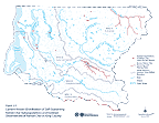
Current Known Distribution of Self-Sustaining Native Char Subpopulations and Isolated Observations of Native Char in King County (741Kb Adobe Acrobat)
This map shows Isolated Observations of Native Char within the Last Decade and Known Native Char Spawning and Rearing Areas. The map is 11" x 8.5", landscape orientation.
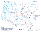
Figure 3.1
Sampling Areas within King County Initially Proposed for Bull Trout Reconnaissance Surveys (671 Kb Adobe Acrobat)
This map displays Stream Reaches Proposed for Reconnaissance Surveys of Native Char. The map is 11" x 8.5", landscape orientation.