
 Translate
Types of landslides along King County river corridors
This project identified the five types of landslide hazards in King County:
Deep-seated landslides
Where fluvial or coastal erosion has created steep, high slopes in glacial sediments, these slopes sometimes fail in large, deep-seated landslides. The segregation of landslides into deep and shallow is somewhat arbitrary and different investigators have used different criteria to differentiate these landslides. For this project, the differentiation follows the criteria proposed by Burns and Madin (2009) that deep-seated slides extend to a depth of more than 15 ft. (4.6 m.). In general this corresponds to individual landslides which are large enough to be distinct on hillshade images generated from LiDAR data. For this mapping, deep-seated landslides may include features where the failure plane is more than 15 ft. deep or where landslide debris accumulates to a depth of more than 15 ft. In King County, a variety of landslide types occur at a scale that may create deep-seated landslides. These styles of deep-seated landslides include:
Each identified deep-seated landslide on the landscape is typically a large and complex feature with different types of movement occurring in different areas of the slide. As a result earth movement on or near deep-seated landslides can manifest in various ways. Often the head scarps of deep-seated landslides are steep, unstable, and subject to secondary landslides, that expand the footprint of the original landslide upslope, The displaced landslide debris in the body of a deep-seated landslide may continue to move over time. If it occurs, such movement is often slow, but over time can result is significant differential displacement.
Examples of the various styles of deep-seated landslides identified using LiDAR are shown below.
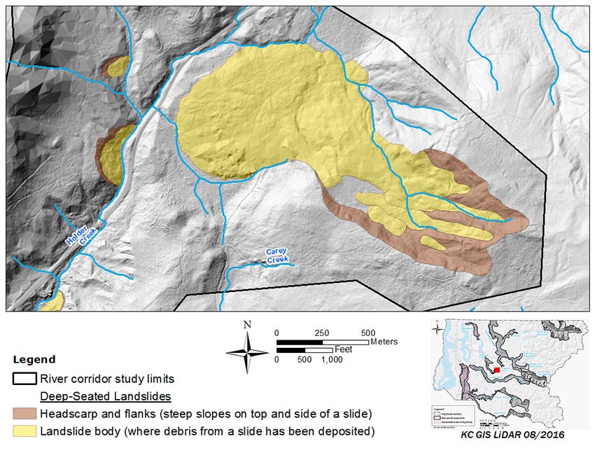
Rock compound slides
A number of occurrences of this style of landslides were identified during this project, mostly in relatively weak Tertiary bedrock in the foothills of the Cascade Mountains. Several of these landslides are quite large, like the one shown in the figure below, with a total length of more than a mile (1.6 km). None of these identified landslides is known to be active although most are located in areas with little development where small movements might go unnoticed.
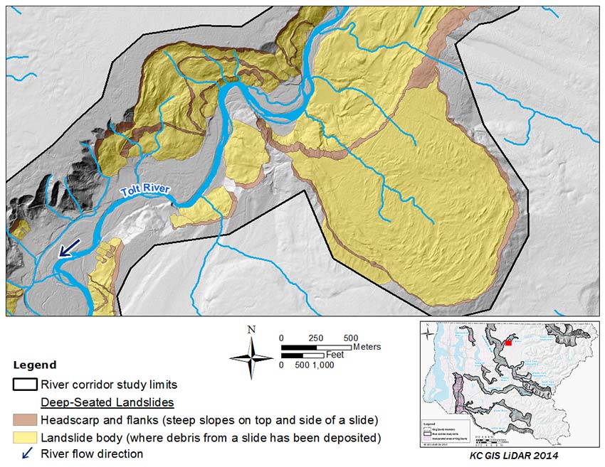
Liquefaction spreads
A landslide of this style was identified on the Tolt River (Dragovich et al. 2009) as part of the Tolt River Landslide Complex. This figure below shows a liquefaction spread near river mile 6.1 to 6.5, on the left valley wall of the Tolt River.
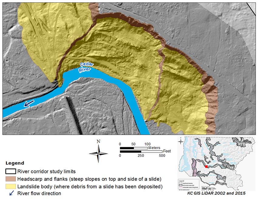
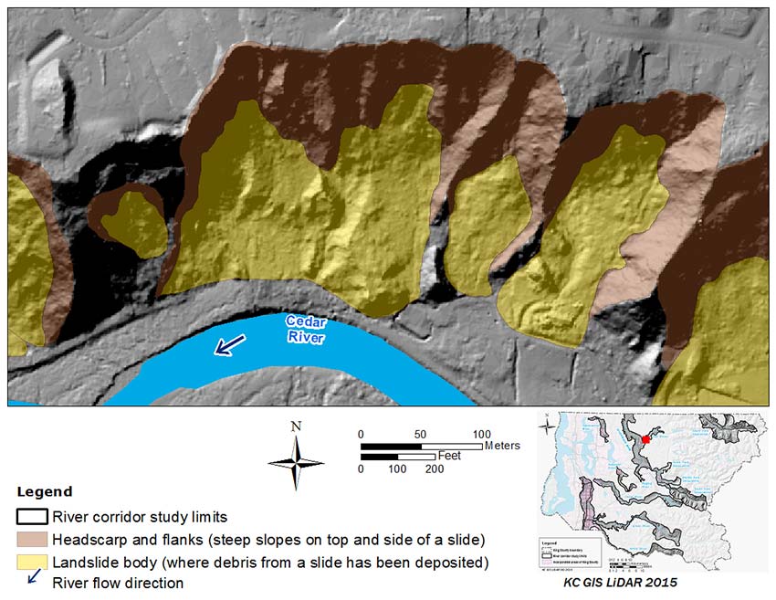
Rotational slide
Rotational slides are also commonly called slumps. In rotational slides, the soil fails on a curved failure plane so that the debris rotates as it moves downslope. In this type of landslide, the soil fails through brittle or plastic deformation without becoming fluidized. This figure below shows a rotational slide near river mile 17.6 to 18.0, on the right valley wall of the Cedar River.
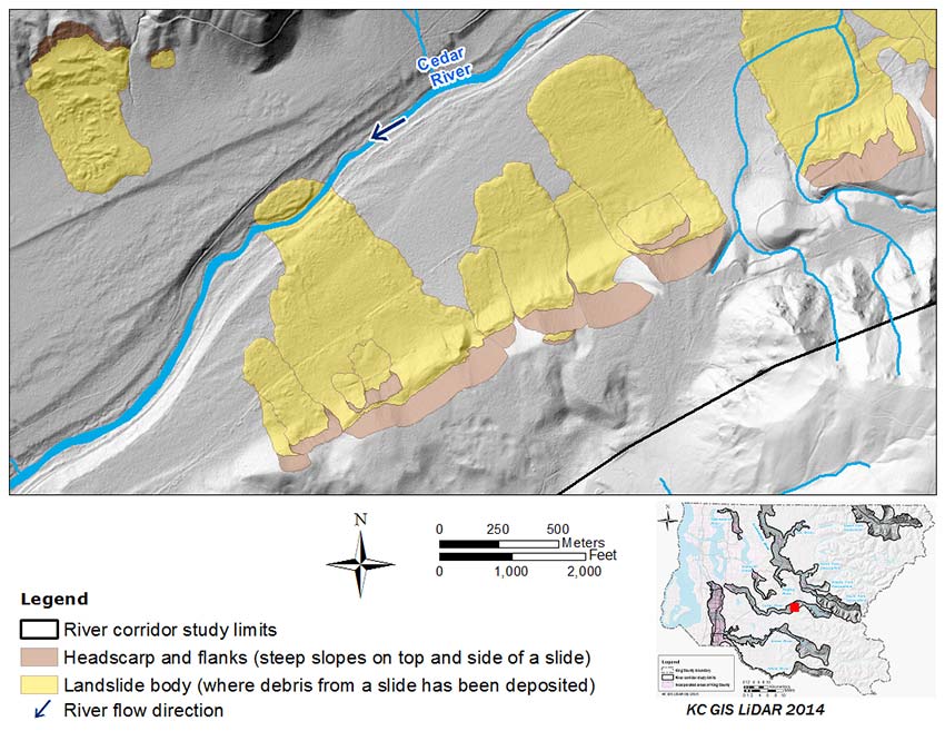
Debris flowslide
In a debris flowslide the debris that is displaced moves primarily in a fluid state. The figure below shows a series of flowslides located in the Cedar River Watershed. The ages of these slides are unknown, but they are geologically very young as they overlap (and therefore post-date) the entire suite of river terraces present here. The exact trigger for this assemblage of large, closely spaced landslides is unclear.
Debris avalanche
In a debris avalanche, the displaced debris moves as a flow but is less fluid than a debris flowslide. This figure below shows debris avalanche near River Mile 5.0 to 5.3, on the right valley wall of the Cedar River. This is the site of the 2001 Nisqually Earthquake-Cedar River landslide.
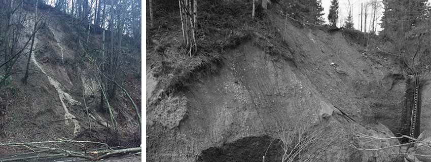
Shallow debris slides
Shallow debris slides (also known as shallow landslides) are a common style of slope movement both in the Puget Lowland and Cascade Mountains. Shallow debris slides are characterized by failure of a relatively shallow layer of soil typically sliding on a surface of more competent material, either bedrock or dense glacial sediments. Shallow debris slides are typically 3 to 6 feet (1 to 2 meters) and translational. Shallow colluvial soils on slopes are formed through a variety of processes, including breaking up of the underlying in-place substrate (either bedrock or Quaternary sediments) by freeze/thaw, wetting/drying, bioturbation, and chemical weathering. Soils on steep slopes in King County vary significantly with respect to soil thickness, soil strength, and hydraulic properties; this variability presents the central challenge in assessing their stability across a landscape.
Shallow debris slides are widespread across the landscape and are common occurrences during periods of high rainfall in both mountain and lowland settings. Shallow debris slides are often triggered by intense rainfall or, in developed areas, discharge of stormwater onto a steep slope. The potential for shallow debris slides is often increased by other human activities including vegetation removal (including logging) and inappropriate fill placement.
Although comparatively small in scale, shallow debris slides can occur on almost any steep slopes anywhere on the landscape. Because this type of landslide is shallow in depth and small in lateral extent, the debris often does not travel a long distance — unless it transitions into a debris flow. But the debris is typically saturated, can move quickly, and often carrying logs or entire trees. Impact and inundation by such debris can be highly destructive in the area of deposition.
Depositional fans
Depositional fans are formed when sediment moving down a steep channel is deposited where the channel gradient abruptly decreases, for example where a steep valley-wall tributary reaches the valley floor. Sediment can be carried down such a steep channel in flow-type landslides (debris flows, debris floods) or as sediment can be carried by streamflow. Fans are subject to a range of hazards depending which of the preceding processes are active. Debris flows and debris floods are two styles of landslide movement that entail landslide debris moving in a fluid state down a channel, often travelling a long distance from the point of origin. Both of these entail landslide debris moving in a fluid state down a channel, often travelling a long distance from the point of origin.
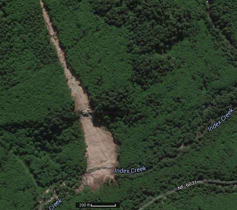
Debris flows
Debris flows often begin as debris slides on steep slopes. If the debris has sufficiently high moisture content, it may liquefy as it is deformed and move downslope as flow. If it reaches a swale, it may continue down the swale as a slurry of water and sediment accumulating additional water and sediment from the swale as it progresses downward. Frequently, logs and other organic detritus are also incorporated into the flow. As the swale reaches the base of the slope there is often an abrupt decrease in the channel slope and sediment that had been entrained in the debris flow is deposited. Over time and with repeated debris flows from a given swale, sediment accumulates in a characteristic fan shape. Debris flows transport a wide range of sediment sizes up to and including large boulders.
In the Puget Lowland, debris flows can also be initiated when there is a sudden high flow of water in a steep channel. One common circumstance where this occurs entails sudden breaching of a beaver-dammed impoundment that releases a flow many times larger than that generated by meteorological events. This type of discharge often causes dramatic erosion and channel incision. Trees and organic detritus from adjacent slopes are often undermined and fall into the flow.
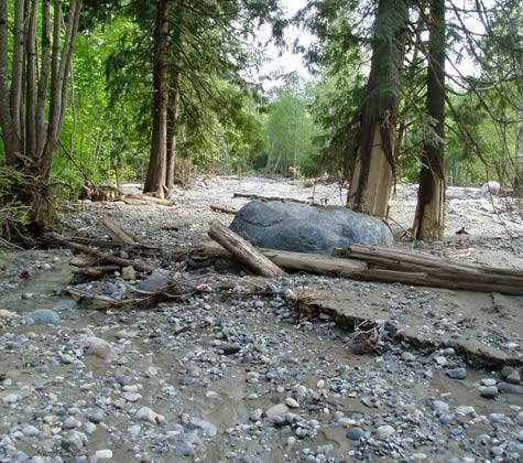
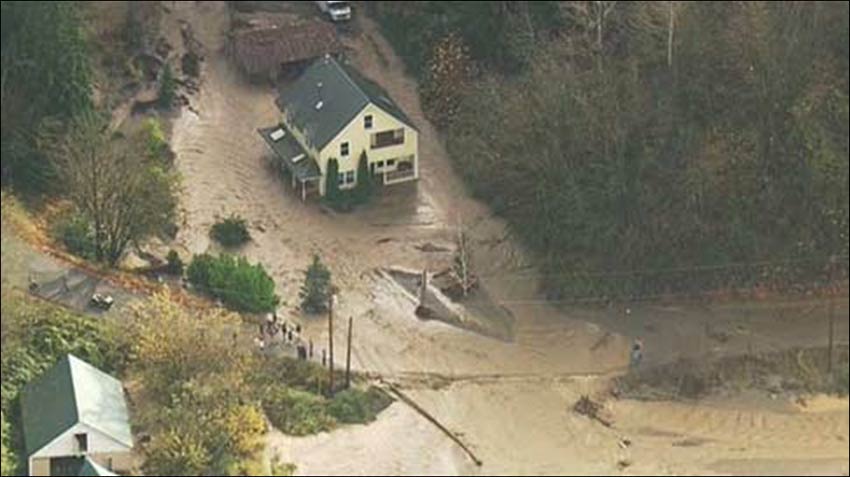
Debris floods
Debris floods are differentiated from debris flows by having a higher water content. Debris floods move smaller-sized sediment, carry less organic debris, and pose less of a safety risk as compared with debris flows. Debris floods are transitional to conventional fluvial flooding. The figure below shows a debris flood caused by a beaver dam failure in 2012 that flowed downslope through and around a home, and over the adjacent street.
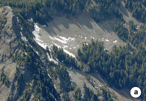
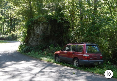
Rock fall
Rock fall is a type of landslide that occurs in bedrock where single or multiple rocks are dislodged and fall from steep cliff faces. In a typical alpine setting, cliffs are located on the upper slopes of a mountain with a talus below, extending to the base of the mountain (see figure "a" below). The talus is composed of rocks that have fallen from the cliff face and accumulate below the cliff. The talus marks the limit of most rock fall from the cliff, but a few boulders that fall from the cliff travel beyond the toe of the talus. It is these outliers that can pose a hazard to adjacent development (see figure "b" below). Rock fall can be triggered by earthquakes, freeze-thaw cycles, or severe weather. Tumbling boulders falling from a cliff face are fast moving and can level virtually anything in their path.
Rock avalanches
Rock avalanche is a style of landslide characterized by the simultaneous failure of an entire bedrock hillslope and with the dislodged mass cascading to the valley below. Rock avalanches move at extremely high speeds and are potentially massive in size. They can extend farther from the base of slope and cover a much larger area compared with individual rock fall.