
 Translate
Landslide hazards in King County
King County now has new, updated mapping information on landslide hazard areas. King County uses landslide hazard mapping information in a number of ways in an effort to identify and address landslide hazard risks that could have impacts on public health and safety.
Landslide hazard mapping information is used as a tool in screening land use applications, in developing capital projects and in preparing emergency response plans and measures. Under the Washington State Growth Management Act and the King County Comprehensive Plan, King County is charged with protecting the natural environment and public health and safety through the protection of environmentally critical areas, including landslide hazard areas. Until recently, the available landslide mapping information in King County was based on 1990 techniques and technology, site specific knowledge of historic landslides and published mapping prepared by other agencies such as the U.S. Geological Survey. As further described immediately below, King County has made use of new approaches and technology to update landslide hazard mapping information.
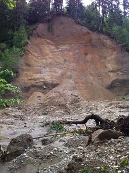
The primary purpose of this map is for use by the Department of Permitting and Environmental Review (DPER) in screening land use and building permit reviews for further geotechnical investigation, and to provide general information to the public and other government entities. As a result of the tragedy at Oso in early 2014, King County Executive Constantine and the King County Flood Control District directed departments to begin a collaborative effort to assess the nature and level of landslide hazards throughout the county. Of principal importance was completion of a map showing potential landslide hazards in unincorporated King County that could replace the 1990-vintage Sensitive Areas Ordinance landslide hazard mapping, which had become outdated. This map is one of the products of that effort and became available June of 2016.
The map is posted as a layer with the Environmentally Sensitive Areas layers on iMap. Click on Layer List/Environmentally Sensitive Areas to find both the potential landslide hazards map and a map of steep slopes. See additional information on the methodology used to create the maps.
Potential landslide hazards shown here include known slumps and other deep-seated landslides, debris fans, rock falls, rock avalanches, snow avalanche zones, undifferentiated and/or indistinct mass wasting features, and landforms suggestive of an increased landslide hazard. All of these features are mapped together irrespective of landslide type, actual hazard levels of individual features, history of past landsliding, and potential risk to structures and residents. This information is provided solely to counsel residents on the possible need for further investigation, such as prior to a proposal for new development.
Landslides also occur in steep slope critical areas (slopes greater than 40% grade) and steep slopes are regulated similarly to landslide hazards. As such, a complete view of all of the potential landslide hazards for a specific property should include a review of the location and heights of nearby steep slopes. Steep slopes are shown on a separate iMap layer. Please refer to that layer for further information.
For general guidance in using this map and specific questions, please contact:
- King County Department of Permitting and Environmental Review at 206-296-6600;
- Greg Wessel, Environmental Scientist/Engineering Geologist at 206-477-0342;
- Steve Bottheim, Environmental Scientist/Engineering Geologist at 206-477-0372.
The King County Department of Natural Resources and Parks has gathered landslide mapping information to assist it in its planning and implementation of capital projects, including flood-risk reduction projects, and in its programs that address flood-related hazards.
This information, gathered by the Department along the mainstem river corridors in King County, is also used for flood warning and emergency response purposes. Landslides along river corridors can deliver substantial quantities of debris into the river channel, thereby blocking the flow of water and producing flooding of homes, businesses and roads. Landslide hazard mapping information along river corridors was requested and funded by the King County Flood Control District. This information about landslide hazards will be used in combination with flood and channel migration hazard mapping to inform decisions regarding the construction of capital projects such as levee setbacks, and non-structural measures such as the acquisition of at-risk homes to reduce impacts on residential neighborhoods, commercial areas, and the public infrastructure that serves these areas.
An interactive web tool displays landslide hazard mapping along the river corridors in King County. This web tool illustrates and provides background information for several types of landslide hazards, including deep-seated slumps, shallow-landslides, debris fans, rock avalanche and rock fall areas.
For general guidance in using the River corridor web tool and specific questions, please contact:
- Sevin Bilir, Geologist at 206-477-4646, in the Science and Technical Support Section.
Other Resources
U.S. Geological Survey Landslides
Washington State Landslide Hazard* program (WA DNR DGER)
Interactive Map: Landslides in Washington (WA DNR DGER)
Landslide Insurance (Washington State Office of the Insurance Commissioner)
Washington State Department of Natural Resources Geology Portal