
 Translate
Levee Breach Study
This webpage includes an overview and anticipated schedule of the Levee Breach Study.
Project overview
This project will identify areas on five rivers in King County where levee systems may be vulnerable to breaching. The five rivers included are the lower Raging, the lower Tolt, the South Fork Snoqualmie, the South Fork Skykomish and the lower Cedar.
The purpose of this study is to identify and evaluate older levees on these rivers. For levees built before the 1990s, there is little information available about when and how they were built. This makes it difficult to determine the potential for breaching. In 2019, King County completed an initial Levee Breach Analysis that:
- reviewed available information on existing levee systems;
- identified data gaps; and
- recommended conducting further investigation to better understand the risk of potential levee breaches.
The current mapping and risk assessment project will fill information gaps, collect additional data, and complete specific studies such as seepage and failure analysis, updated inundation mapping, hydraulic flood hazard (breach) modeling, and risk assessment.
After completing the study, King County, as the primary service provider to the King County Flood Control District, will make recommendations about potential repairs, capital improvement projects, or the need for updates to on-going monitoring and emergency planning.
Study area locations
Study Areas included in the Levee Breach Analysis.
View an expanded image. (PDF, 2.18 MB)
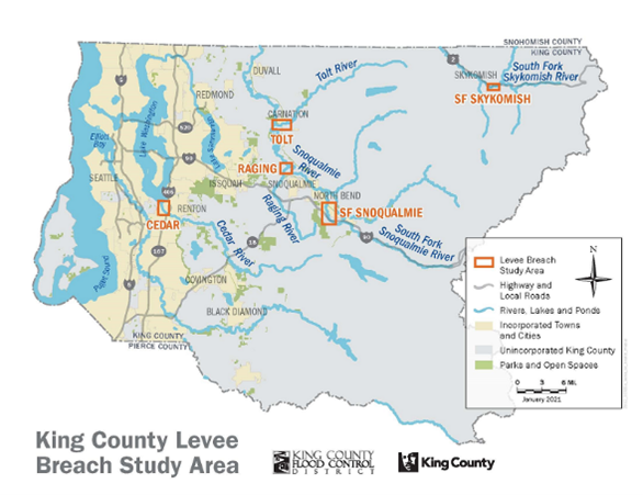
The assessment will occur on five different rivers:
Lower Raging River
The levee system on the lower Raging River consists of a system of levees totaling 2.85 miles, from River Mile (RM) 1.5 (at 328th Way SE) to the confluence with the Snoqualmie River on both banks of the river. These levees are near the town of Fall City.
View the Lower Raging River Map (171 KB)
Lower Tolt River
The levee system on the Tolt River totals 4.27 miles, from River Mile (RM) 2.2 to the confluence with the Snoqualmie River on both banks of the river. The system is near the city of Carnation and recreational and agricultural property.
View the Lower Tolt River Map (268 KB)
South Fork Snoqualmie River
The levee system on the South Fork Snoqualmie River totals 6.25 miles from RM 5.4 (upstream of I-90) to RM 2.1 (Snoqualmie Valley Trail crossing) on both banks of the river. This system is near rural residential property and portions of the city of North Bend.
View the South Fork Snoqualmie River Map (268 KB)
South Fork Skykomish River
The levee system on the South Fork Skykomish River consists of the Town of Skykomish Levee (on the south side of river), which is approximately 0.5 miles in length, and the Town of Skykomish Revetment on the north side of the river. This system is near the town of Skykomish.
View the South Fork Skykomish Map (3.72 MB)
Lower Cedar River
The levee system on the Lower Cedar River consists of a system of levees and floodwalls that extend about 1.2 miles from Interstate 405 to the river mouth where it discharges into Lake Washington on both banks of the river. This system is near commercial, industrial and residential areas within the City of Renton.
Project schedule
| Activity |
Date |
|---|---|
| Project planning |
2020 |
| Gather data - field and desktop analysis |
Early 2021 to early 2022 |
| Computer modeling and risk assessment |
Spring 2021 to spring 2022 |
| Draft study reports |
Summer 2021 to fall 2023 |
| Finalize study reports and share with public |
Fall 2021 to spring 2024 |
Related information
Levee Breach Analysis for King County Rivers report (2019)
"So, You Live Behind a Levee" - American Society of Civil Engineers brochure
Frequently Asked Questions
What is a levee?
A levee is a raised structure built along a riverbank to contain, control, or divert the flow of water and protect the land along the river from temporary flooding. A levee is usually made of earth and runs parallel to the course of a river. Levees can reduce the risk of flooding, but no levee system can completely eliminate flood risk.
What is a levee breach?
A levee breach is a break or gap in the levee that can happen after it is overtopped by floodwaters or has eroded away. If this were to happen, local communities and nearby infrastructure could be at risk of flooding.
Why are you only studying some levees?
This study is focused on containment levees. Only containment levee systems are designed to hold back and convey floodwaters. Other types of flood protection are training levees and revetments, both of which are designed to resist channel migration not inundation.
How can King County improve older levees?
Levees built many years ago are often constructed solely of sand and gravel and can be susceptible to water seepage and erosion during high water flows. Current levees are designed and constructed with engineered materials and have surface erosion protection measures to better withstand high river levels during flooding.