
 Translate
Griffin Creek Natural Area
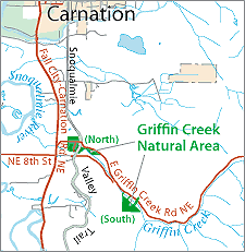
The northern parcel, over 27 acres of forest and former pasture lands, is bisected by the Snoqualmie Valley Regional Trail (SVT) and is directly adjacent to the Archdiocese of Seattle's Camp Don Bosco. This parcel's proximity to the creek, forest lands, and regional trail will provide excellent opportunities for habitat protection as well as for continued low-impact passive recreation. The 19-acre southern group of small holdings is roughly three-quarters of a mile upstream, isolated and undeveloped.
Significant resources at Griffin Creek include:
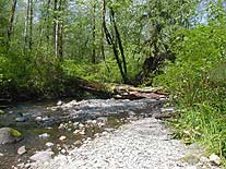
- Griffin Creek, a King County Class I stream system, which provides significant habitat for a number of salmonids including coho and steelhead as well as some of the most concentrated coho spawning densities in the Snoqualmie River system.
- Habitat for terrestrial and aquatic wildlife, including native amphibians.
- Beaver ponds in the creek's main stem.
- Opportunities for the restoration of natural floodplain features as well as enhancement of instream and riparian habitats.
- Natural terraced topography that provides varied levels of public access and potential for restoration.
- Passive recreational, interpretive and educational opportunities adjacent to the Snoqualmie Valley Trail.
 The Griffin Creek Park Natural Area Site Management Plan is available in Adobe Acrobat format. For help using Acrobat files, please visit our Acrobat help page. The document is available in parts to reduce download time and minimize computer problems during and after download.
Download Here:
Griffin Creek Park Natural Area Site Management Plan
Figure 1 - Site Location in Snohomish Watershed
Figure 3 - Existing Conditions
Figure 4a - Natural Resources (North half)