16th Avenue SW: SW 100th Street to SW 107th Street Pedestrian Safety Improvements & Traffic Calming Project

Construction in summer 2025 

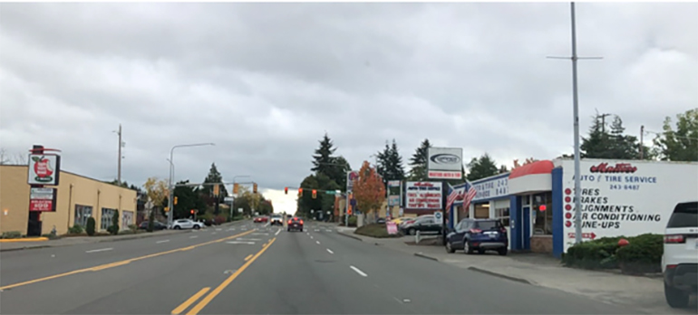
Existing view of 16th Avenue SW approaching SW 107th Street, looking south.

Status update

September 2024

This project is planned to start in summer 2025. In July and August, we asked for feedback on the roadway design for this project. Find out what we heard and view public survey results here.

Upcoming drainage improvement roadwork on 16th Ave SW at SW 104th St in fall 2024:

Crews will replace an underground drainage pipe located on the north side of the intersection at 16th Ave. SW and SW 104th St. The north side of the intersection will be closed for several days because there will be an open pit across the road. Some parking spots on SW 104th St. will be temporarily unavailable during construction. The county will maintain access to businesses and homes at all times. Exact roadwork dates will be posted here and on MyCommute map at least two weeks before the north side of the intersection is closed.

Public outreach update

We recently held a survey to find out if our project design still meets the needs of the White Center community. Thank you to everyone who took the time to respond. Your feedback helps us understand how the project may affect you. The survey took place from July 10 to August 7, 2024. We received 806 responses and 194 comments.  


Survey results

Slightly more than half of the responses we received support the current design that includes bike lanes in both directions. The project also adds a bit more on-street parking on 16th Ave SW than currently exists today. 

2024 survey results 
 
806 survey responses 

Bike lanes & 46 parking spaces: 418

No bike lanes & 67 parking spaces: 356

No answer given: 32


What we heard

There is strong support for slowing traffic and making this busy road safer for everyone—drivers, pedestrians, cyclists, and scooter riders. Additionally, residents expressed the need for more on-street parking, especially in front of businesses without parking lots.  

Concerns were also raised about ensuring long-standing residents and businesses maintain a strong sense of belonging in the area.  

What we are doing

This project gives us an opportunity to make 16th Avenue SW safer for everyone. The county has decided to proceed with the current design, which includes bike lanes.  

Bike lanes, along with the other pedestrian safety improvements, help reduce the chances of accidents between vehicles and people on foot, bicycle or scooter.  Bike lanes also keep bicycles off the main road, which helps traffic flow more smoothly and safely. Learn more about our decision-making process.

Community involvement and collaboration

The county worked with community members, businesses, and residents throughout the project. We joined community meetings and White Center events and also ran two major outreach campaigns. We conducted two online surveys—one early in the design process and another at the final stage. 

Upcoming meeting with community leaders 

Your feedback is important for improving our collaboration on this road safety project and other King County projects. We are planning a meeting with White Center community leaders in early fall to work together more closely. If you or someone you know would like to join, contact us at AskLocalServices@kingcounty.gov or call 206-263-1189.

Overview

This project will make it safer for people to travel along 16th Avenue SW between SW 100th Street and SW 107th Street in White Center. King County will add safer street crossings, clearer signs and road improvements to help reduce speeding. 

The roadway will undergo restriping to have one vehicle travel lane and a dedicated bike lane in each direction. There will also be a center turn lane down the middle of the road. 

Construction is scheduled to begin in summer 2025.


24/7 Road Helpline

24/7 Road Helpline

Call us for help at 206-477-8100 or 1-800-527-6237 with road maintenance and traffic safety issues in unincorporated King County — 24 hours a day

Project map


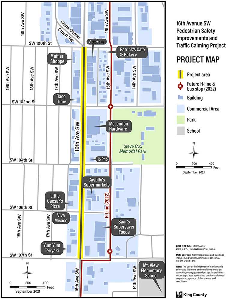
This project improves pedestrian safety along 16th Avenue SW between SW 100th Street and SW 107th Street. View larger image (106KB).

This project improves safety for pedestrians and calms traffic
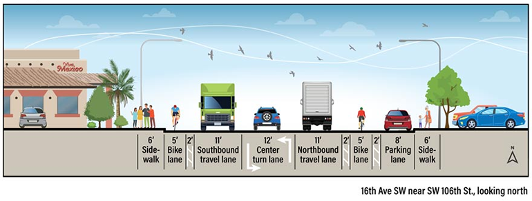
 

The image above shows what 16th Avenue SW between SW 100th and SW 107th streets will look like once the project is complete. The road will be restriped to have one 11-foot-wide travel lane and one bike lane in each direction. There will be a center turn lane down the middle of the road, and an eight-foot (8-foot) wide parking lane on the east side of the road. View larger image (49KB)

Safety improvements coming to 16th Avenue SW

This project will calm traffic and improve pedestrian safety by providing the following:

  • One lane in each direction
    This will help prevent speeding by slowing down traffic and makes crossings safer for people walking.
  • Center turn lane
    Provides a safer place for drivers to make left turns. This will allow traffic to move freely in the main travel lane.
  • Sidewalk curb extensions at SW 104th Street and SW 106th Street intersections
    There are no traffic signals at these two intersections to stop traffic. Sidewalk curb extensions will help drivers see people walking in the crosswalk. The extensions also will shorten the distance people need to cross.
  • Rapid flashing lights and new pedestrian crossing signs at intersections that do not have a traffic signal
    Flashing lights and high-visibility signs will alert drivers when pedestrians are crossing 16th Avenue SW at SW 104th and SW 106th Street.
  • Bicycle lanes in both directions
    New, five-foot (5-foot) wide bicycle lanes will separate bike riders from motor vehicle traffic. This will give people on bikes or other active transportation more room so that they don’t have to share the road with cars. 
  • Two feet of extra space (buffer zone) on both sides of bike lane 
    Cyclists feel more comfortable and secure when they are not too close to moving traffic or parked cars. A two-foot (2-foot) wide buffer zone on both sides of the bike lane could help encourage more people to choose biking or other types of active transportation to get to where they want to go.

Graphic showing crosswalk pedestrian improvements.

Changes to on-street parking

Currently, there are 43 parking spaces on 16th Avenue SW between SW 100th and SW 107th streets. The total number of parking spaces in the project area will likely stay the same, but their locations might change. For instance, parking spaces currently on the west side of the road may be moved to the east side. This shift is necessary to accommodate new bike lanes, sidewalk curb extensions, and safety improvements.

Why is this project needed?

16th Avenue SW, is important for people walking, biking, and driving. However, it is currently more focused on cars and trucks than pedestrians or cyclists. We want to make this part of 16th Avenue SW safer for everyone. There have been 26 collisions with pedestrians reported in this busy area between 2011-2023. Studies show that the safety improvements like the ones included in this project can reduce the number of collisions up to one-third.

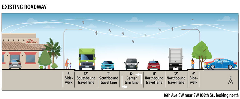
Existing roadway layout 

The image above shows what 16th Avenue SW between SW 100th and SW 107th streets look like today. The road currently has two travel lanes in each direction and a center turn lane. There are no bicycle lanes on this road. View larger image (55KB)
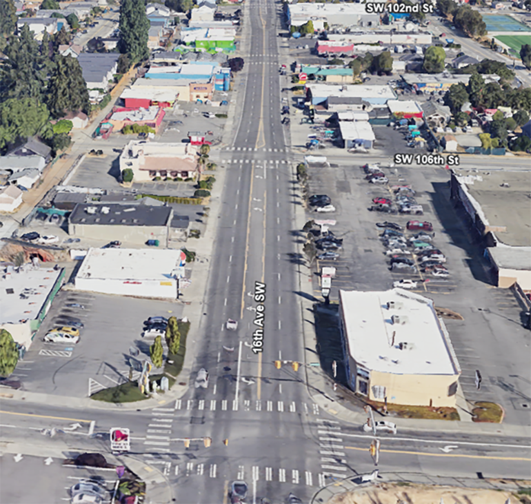

Google Earth photo of 16th Ave. SW between SW 107th and SW 102nd streets looking north (photo taken in 2022). The existing road layout is built more for car traffic than people walking or biking. 


Higher speeds can result in more collisions with pedestrians.

Roads with a single travel lane in each direction and a center turn lane have slower, calmer traffic. This is important for pedestrians and cyclists because slower vehicle speeds make it safer, reducing the risk of injury and death.

  • Fewer travel lanes make it safer to cross the street and allow room for sidewalk curb extensions and buffered bicycle lanes.
  • Sidewalk curb extensions reduce the crossing distance for pedestrians in the crosswalk.
  • Extra space, or buffer zone, on both sides of the bicycle lane provides a dedicated place for non-motorized traffic.

Project budget and funding

The total estimated project cost is $1.9 million. The project is funded by COVID Relief grant money, a grant from the national Highway Safety Improvement Program, and local funds.

Project timeline

  • Preliminary design complete: Late 2021.
  • Initial public outreach and comment period complete: Spring 2022.
  • Final design complete: Winter 2024
  • Ongoing public outreach: 2022 through 2025.
  • Construction: Summer 2025
  • Project complete: Winter 2025

Community involvement 

Early project design - Winter and spring 2022  

The county worked with community members, businesses, and residents throughout the project. We joined community meetings and White Center events and also ran two major outreach campaigns. We conducted two online surveys—one early in the design process and another at the final stage.
 
King County conducted an outreach campaign and survey to collect input from over 800 community members. Two potential project design options were presented to the community for their consideration. 

  1. Design option 1:
    • One travel lane in each direction and a center turn lane
    • Dedicated lanes for bicycles in both directions.
    • No change to on-street parking. Same number of existing parking spaces (46 spaces).
  2. Design option 2:
    • One travel lane in each direction and a center turn lane
    • No dedicated lanes for bicycles.
    • Adds more street parking on both sides of the road.

Over half of the survey participants chose Design option 1 the best fit for the community’s needs. As a result, the County proceeded with this chosen design.

Late project design – Summer 2024

We held a community outreach meeting on July 24, 2024, and conducted a survey in July and August 2024. Slightly more than half of the 806 responses we got supported including bike lanes in both directions, along with other pedestrian safety and traffic calming measures included in the final design. 

  • View community meeting presentation here. Contact Shunneia Long-Mattingly at slongmattingly@kingcounty.gov or call 206-263-2803 to get a copy in another language or alternate format.
  • View survey results here.  

Why the county decided to include bike lanes

Our goal is to help everyone, including people who need extra time in the crosswalk, to get across the road safely. We added bike lanes along with curb extensions and bright yellow flashing signs to help slow down traffic and protect people from the danger of getting hit by a moving vehicle.

Our decision-making process focused on saving lives and listening to what the community had to say. We also paid attention to concerns about parking, especially from businesses in downtown White Center.

During the early design phase in winter and spring 2022, we gave the community two options. One included bike lanes and about the same amount of parking as now. The other option had more parking but no bike lanes. Both options got almost the same level of support, but more people said they wanted bike lanes. Because of this, and advice from traffic safety experts, we decided to add bike lanes to the project.

In July and August 2024, the project design was nearly finished. We held another project survey to make sure residents, workers, and business owners were aware of the project, and to see if our decision to include bike lanes still met the needs of the community. The feedback showed that just over half supported bike lanes in both directions. This matched what we heard in 2022.

While surveys give us helpful information, they aren't always perfect. Since our main goal is to keep everyone safe, and bike lanes have been shown to reduce accidents and make traffic flow better, we decided to move forward with the current design that includes bike lanes.

Frequently asked questions

We are focusing on this section of 16th Avenue SW to calm traffic and make it safer for everyone. This busy section of 16th Avenue SW has the highest number of collisions involving pedestrians. More than 22 accidents have been reported between 2011 and 2020. Traffic studies have shown that the types of safety improvements included in this project can reduce the number of crashes by 33 percent.

You can view King County’s Transportation Needs Report (TNR) for more information on transportation improvement needs in unincorporated King County. It is a component of the King County Comprehensive Plan and fulfills state requirements as specified in the Washington State Growth Management Act. The latest version of the TNR was adopted by the King County Council on July 24, 2020 as part of the 2020 King County Comprehensive Plan update.
On a four-lane road, drivers stop in the left-hand lane to make left turns, increasing the risk of being struck by a driver using the left lane to go straight. When the road is changed to have two travel lanes and one center turn lane, the center lane provides a dedicated place for left-turning vehicles to wait. This allows traffic to move freely in the main travel lanes. In addition, one main travel lane in each direction helps to slow traffic. Fewer crashes happen when traffic is calmer.
Roads with three lanes have slower, calmer traffic, which is especially important for vulnerable users like pedestrians and people biking. The risk of injury and death to these users decreases as vehicle speeds decrease. Fewer travel lanes allow room for sidewalk curb extensions and buffered bicycle lanes. Sidewalk curb extensions reduce the crossing distance for pedestrians in the crosswalk. Buffered bicycle lanes provide a dedicated place for non-motorized traffic.
No, the new lanes will be able to carry the traffic volumes that are existing on 16th Avenue SW. This means traffic will flow freely, but the overall speed of traffic will be slower.
The project includes a dedicated center turn lane at intersections that have a traffic light. Left turn signals and a dedicated center turn lane help reduce collisions at intersections. Trucks longer than 40-feet in length will use the signalized intersections at SW 100th, SW 102nd and SW 107th streets to turn since there will be no curb extensions (bulb-outs) added at these locations.
The project includes the following American with Disabilities Act safety features:
  • Countdown pedestrian signal heads will let pedestrians know how much time remains to cross the intersection
  • Audible messaging will inform pedestrians which crossing has a “walk”
  • Vibration and tactile surfaces at crosswalks and intersections will also inform pedestrians which crossing has a “walk”
  • High visibility pedestrian safety signs make it easier for drivers to know when to expect pedestrians
  • Accessible ramps help people with disabilities, people pushing strollers, and others, access the crosswalk
This project adds a five-foot (5-foot)-wide bike lane and a minimum two-foot (2-foot) striped buffer space between the bike lane and the vehicle lane or parking spaces. Buffered bike lanes provide more space for people using bikes or other forms of non-motorized transportation, so they aren't sharing space with moving motor vehicles. The bike lanes and striped buffer areas also will help riders avoid opening car doors.
The existing 25 MPH speed limit increases to 30 MPH at SW 100th Street. This project may extend the 25 MPH speed limit on 16th Ave SW between SW 100th and SW 107th streets, pending additional study of how traffic moves through the area. We are considering a speed limit reduction between SW 100th and SW 107th streets.
expand_less