
 Translate
State Route 169 to begin reopening tonight, Oct. 20, as work wraps up on critical flood risk reduction project
Summary
A single lane of State Route 169 in Maple Valley will reopen at approximately 8 p.m. Wednesday, Oct. 20, with a full reopening of the highway by 5 a.m. on Thursday, Oct. 21 as crews complete a flood risk reduction project designed to reduce the likelihood of another flood forcing an emergency highway closure.
Story
Work is wrapping up on a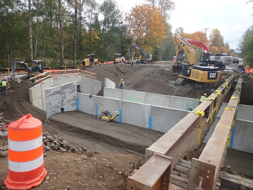 major project to reduce the risk of flooding and potential emergency closures of State Route 169 north of Cedar Grove Road in Maple Valley. As of approximately 8 p.m. on Wednesday, Oct. 20, one lane of the highway will open with flaggers directing traffic.
 Both lanes of the highway will be open by 5 a.m. on Thursday, Oct. 21. Drivers should expect to see additional overnight lane closures as crews complete shoulder work in the coming days. King County’s Cedar River Trail will also reopen on Thursday.
The project replaced undersized and restrictive culverts under State Route 169 and the Cedar River Trail, which couldn’t accommodate all of the runoff during high-rainfall events. Most recently, heavy rainfall in February 2020 led to flooding at this location that closed the highway to all traffic for five days and isolated several nearby residences.
The King County Flood Control District funded the repair to replace 18-inch culverts with 15-foot-wide box culverts, which improve fish passage in addition to minimizing localized flood risks.
Construction on the project was unexpectedly delayed beyond the weekend after the discovery of a wooden-plank road at the project site that halted work until the structure could be evaluated to meet legal obligations for historic preservation purposes.
Additional project information is available at kingcounty.gov/SR169FloodReduction.
Residents in unincorporated King County can get real-time traffic information by checking the My Commute Map and by following the @kcroads on Twitter. Travelers can also find updated traffic information on the @WSDOT_traffic Twitter feed, and with WSDOT Travel Alerts.
###
The King County Flood Control District is a special purpose government created to provide funding and policy oversight for flood protection projects and programs in King County. The Flood Control District’s Board is composed of the members of the King County Council. The Water and Land Resources Division of the King County Department of Natural Resources and Parks develops and implements the approved flood protection projects and programs. Information is available at kingcountyfloodcontrol.org/.