
 Translate
Pacific Right Bank Flood Protection Project
Project overview
The Pacific Right Bank Flood Protection project is located on the right bank of the White River in the City of Pacific. The project will extend from the BNSF Railway south to the King-Pierce County boundary line, as shown on the map below. The King County River and Floodplain Management Section is overseeing the design and construction of this project as service provider to the King County Flood Control District.
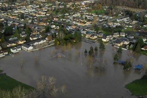
Severe flooding along the right bank of the White River in January 2009 affected the neighborhood communities of White River Estates, Third and Fourth Avenues, and Pacific City Park.
White River flooding has worsened over time because of sediment build up in the river channel. King County installed HESCO barriers as a short term-solution to increased flood risk in the area. HESCOs are large containers of sand, soil, or rocks/gravel that serve as a flood control. In the map above, they are noted by the green line. The Pacific Right Bank Flood Protection project will investigate ways to substantially reduce the potential of White River flooding in the City of Pacific.
Project site investigations are conducted through an environmental review process called SEPA. Four different project alternatives are being considered for further study in a draft Environmental Impact Statement (EIS), in addition to a no-action alternative.
All four alternatives will consider environmental impacts and opportunities to restore habitats for the endangered Chinook salmon, create other wildlife habitats, and support potential park and river recreational uses.
As part of the Pacific Right Bank Flood Protection Project, King County has been investigating a former dumpsite under Pacific City Park for cleanup under the guidance of the Washington State Department of Ecology’s (Ecology) Voluntary Cleanup Program. King County is conducting additional soil, groundwater, and vapor sampling as part of the multi-step dumpsite investigation.
Project goals
- To substantially reduce the potential for White River flooding in the City of Pacific.
- To improve environmental conditions along this portion of the White River.
Project schedule
| Activity |
Date |
|---|---|
| Installed flood risk reduction measures (HESCO barriers) |
October 2009 |
| Started property acquisition |
December 2009 |
| Installed additional HESCO barriers (extension and height) |
November 2013 |
| Started feasibility studies |
October 2014 |
| Public scoping process completed |
April 2018 |
| Conduct environmental review (SEPA) process |
2017 to 2023 |
| Select preferred alternative for design |
2024 |
| Project design |
2022 to 2025 |
| Target for construction |
2026 to 2029 |
Project documents
Frequently Asked Questions (308 KB, PDF)
Preguntas frecuentes (70 KB. PDF)
Часто задаваемые вопросы (182 KB)
Hydraulic Modeling and Geomorphic Response Assessment, 2021 (34.0 MB, PDF)
Government Canal Pump Station Alternatives Analysis Technical Memorandum, 2021 (7.32 MB, PDF)
Alternatives Analysis Technical Memorandum, 2020 (10.6 MB, PDF)
Wetland and Ordinary High Water Mark Delineation Report, 2019 (12.6 MB, PDF)
Remedial Investigation Report: Pacific City Park, 2019 (60.79 MB, PDF)
Supplemental Remedial Investigation Report: Pacific City Park, 2019 (34.55 MB, PDF)
Pacific Park Environmental Investigation, 2017 (9.07 MB, PDF)
Pacific Park Phase II Environmental Site Assessment, 2016 (19.11 MB, PDF)
Pacific Park Phase I Environmental Site Assessment, 2015 (23.69 MB, PDF)
Determination of Significance and Scoping Notice, March 2018 (119 KB, PDF)
Environmental Scoping Report, August 2018 (4.23 MB, PDF)
Additional project documents available by request: mstrazer@kingcounty.gov