
 Translate
Willowmoor Floodplain Restoration Project
Project overview
Sammamish River Transition Zone during October 2022 facility inspection - looking upstream.
The Sammamish River used to flow across a wet valley that provided natural flood storage. In the early 1900s settlers drained wetlands and straightened the river for farming. In 1964, the U.S. Army Corps of Engineers expanded these efforts in the 14-mile-long Sammamish River Improvement Project (Flood Project) that connects Lake Sammamish to Lake Washington. The Flood Project widened the river channel and deepened it by up to six feet. It provides spring flood protection to the Sammamish River valley and Lake Sammamish.
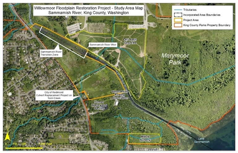
The Transition Zone is a water way within the Flood Project that connects Lake Sammamish and the Sammamish River. Located at River Mile 13.0-13.5 of the Sammamish River in Marymoor Park, the Transition Zone provides some lake level control as well as downstream flood protection. During low lake levels, river flow is contained within a 30-foot-wide channel in the center of the Transition Zone. At high lake levels, river flow occupies the full 200-foot width of the Transition Zone. The area is important for Chinook salmon and other fish and wildlife. Willow trees planted along the Transition Zone in the late 1990's improved habitat for salmon.
At the upstream end of the Transition Zone, a weir (a small barrier built across a river) controls lake outflow, maintaining summer lake levels. A notch in the weir provides passage for Chinook salmon and other fish. At most flows, the notch in the weir also allows passage for small boats, such as canoes and kayaks. During high lake outflows, flow control shifts from the weir to the Transition Zone.
Over the years, more frequent high lake levels have occurred. King County crews began annual vegetation maintenance in the Transition Zone in 2011. This ongoing maintenance - trimming willows along the stream corridor and mowing native grasses in the high flow channel - allows the project to meet its performance standards. Unfortunately, it degrades habitat for fish. Additionally, warming water from Lake Sammamish outflow threatens salmon.
Purpose
The Willowmoor Project will improve flood control and habitat in the Sammamish watershed. The project is in Marymoor Park near Lake Sammamish. This project is sponsored by the King County Flood Control District (District).
Outflow from the lake through the Transition Zone has decreased over time. Development, heavy rainfall, and vegetation management are all culprits. The County started a vegetation management program in 2011. But that, in turn, harmed salmon habitat. It also resulted in the District facing high mitigation costs.
The Willowmoor Project aims to reconcile these issues. The District selected a preferred alternative in 2016.
Learn more about Sammamish River history
Did you know that the Sammamish River was once part of an ancient lake connecting Lake Washington and Lake Sammamish?
For an interactive Sammamish River history experience visit the Sammamish River StoryMap.
Project area
The Willowmoor Project proposes to reconfigure the Transition Zone. The project area includes the river channel and adjacent undeveloped land to the southwest (left bank) of the river channel. Some minor improvements are also planned for portions of the land northeast of the river channel in the current Marymoor off-leash dog park area
Project alternatives
In 2013, King County developed design alternatives to address the project goals. Public engagement was a significant element of the design process. Design alternatives were developed based on design objectives, technical studies, and public comment.
Links to design alternatives (for help with PDF files, visit our Acrobat Help page):
“No Action” (Maintenance) (1.3MB)
Widened Existing Channel + Surface Water Heat Exchange (4MB)
Split Flow Channel + Pumped Groundwater (5.4MB)
Typical Cross-Section Views of Alternatives (746KB)
The Flood Control District selected the "Split Flow Channel + Pumped Groundwater" alternative for further consideration. This design creates a new side channel connected to the main channel up and down stream of the Transition Zone. The Tosh Creek tributary would tie into the new side channel. The project team has hired a consultant to bring the project to draft 30 percent design by the end of 2018.
Concept Alternatives Analysis, April 2019 (4.9MB)
Concept Alternatives Analysis Appendices, April 2019 (37MB)
Project schedule
Updated October 2022
| Activity |
Date |
|---|---|
| Project start |
May 2013 |
| Stakeholder advisory committee process |
August 2013 to April 2015 |
| Technical studies |
June 2013 to early 2016 (estimated) |
| Design objectives and criteria development |
October 2013 to May 2014 |
| Draft alternatives development |
April 2014 to April 2015 |
| Preferred alternative selection and approval |
October 2015 to July 2016 |
| Preliminary (30%) design |
April 2018 to December 2024 |
| Stakeholder/community engagements on 30% design |
January 2025 to June 2025 |
| Final design and permitting |
To be determined |
| Construction |
To be determined |
Project documents
Project History
1960’s Design Documents for the Sammamish River Improvement Project
Operations and Maintenance Manual
1998 US Army Corps of Engineers Weir Revision Documents
2002 Sammamish River Corridor Action Plan
Sammamish River Corridor Action Plan
2003 Willowmoor Floodplain Restoration Project
Willowmoor Floodplain Restoration Project Conceptual Design Report
Current Project
2015-2016 Conceptual Design and Alternatives Analysis
2015 Willowmoor Conceptual Design Summary Report
Willowmoor Floodplain Restoration Project DRAFT Alternatives Considerations Memo (5.7 MB)
Summary Report Appendices, April 2015 (17.7MB)
Willowmoor Floodplain Restoration Project Concept Design Summary Report, April 2015 (14.5 MB)
Flood Control District Executive Committee Motion 2016-04.1
2019 Project Design - Side Channel and Weir Configuration Options
Willowmoor Floodplain Restoration Project - Preliminary Dynamic Weir Analysis Technical Memorandum, September 2018 (2.49MB)
Concept Alternatives Analysis, April 2019 (4.9MB)
Concept Alternatives Analysis Appendices, April 2019 (37MB)
Frequently Asked Questions, February 2019 (700KB)
2021-2023 Watershed Studies and Peer Review
Flood Control District Executive Committee Motion 2021-03
Lake Sammamish Stormwater Controls Feasibility Study and Cost-Benefit Analysis Report, July 2023
Lake Sammamish Lakeshore Flood Risk Assessment Report, July 2023
Lake Sammamish Flood Forecasting Report, July 2023
Community engagement
- January 27, 2013 - First public meeting was held in Marymoor Park to kick off the Willowmoor Project.
View the presentation (2MB) - August 2013 - The District convened a Stakeholder Advisory Committee (SAC) to provide input through selection of a preferred design alternative.
- June 6, 2016 - The District held a special Executive Committee meeting in Bellevue to help inform the decision about which alternative will move forward for further design.