
 Translate
Reference maps
Reference maps
Below you will find our archive of reference maps for Unincorporated King County.
|
|
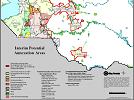
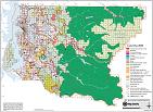
Interim potential annexation areas
|
Published: 09/15/2009 |
|
|
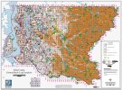
King County comprehensive plan land use
|
Published: 01/14/2009 |
|
|
|
Published: 11/20/2006 |
|
|
|
Published: 09/01/2013 |
|
|
King County ground snow load (four sections)
|
Published: 02/15/2005 |
|
|
Generalized comprehensive plan land use
|
Published: 02/14/2005 |

Additional maps
Maps pertaining to noxious weeds, water resources, water and sewer utility areas, wastewater treatment and watersheds, and freshwater distribution of salmon and trout.
King County Natural Resource maps
Maps pertaining to County Council Districts, School Districts, and other minor election districts.
Maps produced by other King County Departments.