
 Translate
Duwamish River Valley Groundwater Study
Learn about the Duwamish River Valley Groundwater Study that will help King County understand how groundwater in this coastal area is impacted by climate change, flooding, and tidal changes.
King County is working on a short-term study in the Duwamish River Valley to better understand how groundwater in this coastal area is impacted by climate change, flooding, and tidal changes.
The groundwater study will help the Wastewater Treatment Division (WTD) develop an approach to manage the effects of sea level rise on our communities and infrastructure.
Why study groundwater?
WTD owns and operates pipes, pump stations, and treatment stations in the Duwamish Valley. This infrastructure is critical to collecting and treating wastewater from South Park, Georgetown, and the greater Duwamish River communities.
During higher river flows or severe rainstorms, groundwater levels can rise closer to—and sometimes above—the ground surface. This can cause river and flood waters to overload the wastewater system. When the tide is abnormally high or driven by storm surges, salt water can move up the river and inland underground and enter our wastewater system. Rising groundwater levels and the presence of salt water are known to cause damage to pump stations and pipes.
With the impacts of climate change projected to grow more frequent and intense, we must prepare for sea level rise by making science-based investments that protect our communities and infrastructure. This study will help us do so.
Study area
.png?h=931&w=770&rev=69cea90a2b524873b240fb526df7b62e&hash=B377F06D9148E1E29B4A4574B31CA53A)
The Duwamish River valley study area covers many jurisdictions with a variety of land uses and infrastructure, including flood facilities, wastewater treatment facilities, airports, commercial areas, public lands, and residential neighborhoods.
Project update
February 2024
WTD launched a project to study groundwater responses to climate, river, and stormwater flooding and tidal events focused on the Duwamish River Valley. WTD is conducting this project in partnership with the U.S. Geological Survey (USGS).
Field work to identify monitoring wells and collect groundwater data from the wells began in December 2023 and will continue through February 2024.
View translated documents and content in translated languages.
Schedule
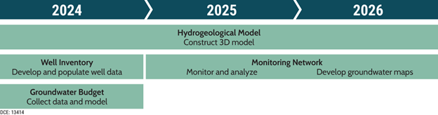
The study is expected to take 3.25 years to complete. Data collection (water-level and specific-conductance measurements) will begin as soon as monitoring wells are selected and will take 1.5 years to complete. The groundwater-budget model and development of the hydrogeologic framework will provide more information on the current state of groundwater by collecting existing groundwater data and creating a conceptual groundwater model. This step will take 1.5 years. The results of the study will be published in the final 6 months of the project.
Interactive map of groundwater monitoring wells
The following map shows the location of groundwater monitoring wells throughout the study area. USGS will collect water-level data as soon as monitoring wells are selected. All water-level data collected will be published in the publicly accessible USGS database (https://waterdata.usgs.gov/wa/nwis/nwis).
Resources
- All data collected by USGS will be made publicly available on the USGS National Water Information System (https://waterdata.usgs.gov/wa/nwis/nwis) database soon after collection.
- US Geological Survey website on King County’s Lower Duwamish River Valley Groundwater Study
- Groundwater study of the Duwamish River Valley, Washington, USGS
- [Chinese] Washington 杜瓦米什河谷(Duwamish River Valley) 地下水研究
- [Vietnamese] Nghiên cứu nước ngầm ở Thung Lũng Sông Duwamish, Washington
- [Somali] Daraasadda biyaha dhulka hoostiisa ee Duwamish River Valley, Washington
- [Khmer] ការសិក្សាអំពីទឹក្សក្រកាមដីនៃររលង Duwamish River Valley ទីរក្ស ុង Washington
- [Spanish] Estudio de aguas subterráneas del Duwamish River Valley, Washington