Moss Lake Natural Area
Site Management Guideline

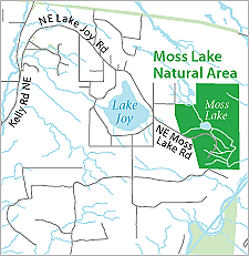
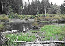
Moss Lake Natural Area is a King County Department of Natural Resources and Parks (DNRP) Ecological Land. The site is located 5 miles southeast of Duvall, 3.5 miles northeast of Carnation, and 1 mile east of Lake Joy in the Cascade foothills. The site is comprised of 372 acres of high-quality wetland and forested upland habitats. An extensive Class 1 wetland complex encompasses a large sphagnum bog, beaver dams, open water and forested wetland.

Moss Lake NA receives a modest amount of public use. There is a limited trail system on the site, and users include hikers, equestrians and mountain bikers. There is a pit toilet and a parking lot for up to 16 cars or 10 cars and three busses.
The Moss Lake Natural Area Site Management Guidelines are available in Adobe Acrobat format. For help using Acrobat files, please visit our Acrobat help page.
Download Here:
Moss Lake Natural Area Site Management Guidelines (1.2 Mb)
- Figure 1 - Location Map (350 Kb)
- Figure 2 - Aerial Photo Map (1.2 Mb)
- Figure 3 - Aerial Parcel Map (1.2 Mb)
- Figure 4 - Topographic Hillshade Map (3.3 Mb)
- Figure 5 - Soils Map (64 Kb)
- Figure 6 - Hydrography Map (922 Kb)
- Figure 7 - Survey Map (1.2 Mb)
- Figure 8 - Roads and Trails Map (1.2 Mb)

 Translate