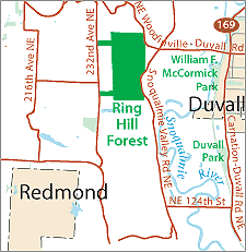
We currently offer language translations on our site primarily through Google Translate. This helps visitors find and use information in the languages they speak, but the tool is not perfect. Automated translation may be inaccurate or errors may display on translated pages.
Google Translate is an external website. King County does not control the quality or accuracy of translated content.
Ring Hill Forest is a King County working resource land. The property lies west of West Snoqualmie Valley Rd. near its intersection with NE Woodinville-Duvall Rd. and to the east of 232nd Ave NE near its intersection with NE 147th St. Working resource lands play an important role in sustaining agriculture and forestry activities by creating contiguous tracts of working forest and agriculture lands, educating the public about working landscapes, and providing limited passive use recreation opportunities.
Ring Hill Forest is 320 acres of rural forestland located on the western valley wall above the Snoqualmie River. The forest slopes from the plateau in the west steeply to the Snoqualmie Valley floor to the east. Ring Hill was acquired to conserve rural forestlands, provide a buffer between rural residential development and agricultural uses in the Snoqualmie Valley, and provide revenue while demonstrating sustainable forestry. The land was originally harvested in 1911 and again between 1962 and 1965. The stand was primarily high-graded, leaving undersized, deformed, and diseased coniferous trees. The Ring Hill Forest Stewardship Plan is focused on creating a diverse, vigorous, and healthy forest that provides habitat as well as revenue.
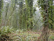
The Ring Hill Forest Stewardship Plan and associated maps are available in Adobe Acrobat format. For help using Acrobat files, please visit our Acrobat help page.