
 Translate
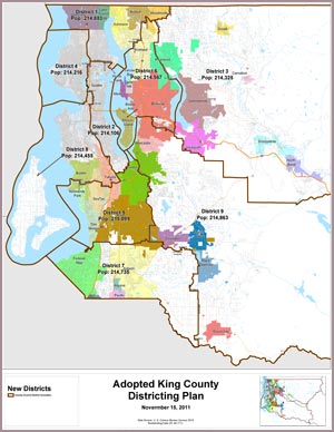
Adopted Districting Plan
Unanimously approved November 15, 2011
 JPG Maps (medium-resolution, 0.5MB)
PDF Maps (high-resolution vector, 5MB)
- New and old boundaries with annotations
- New and old boundaries
- New boundaries
- New: New boundaries (KC Dept. of Elections)
Interactive Maps
Tables
- District City Profile (0.1MB)
- District Race and Ethnicity Profile (0.1MB)
Raw Data
- Census block assignment data (0.2MB)
- Shape file (0.2MB)