
 Translate
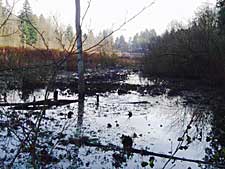
Bingaman Pond Natural Area
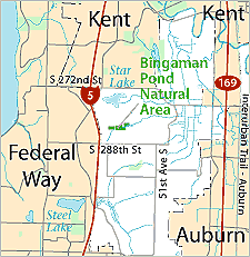
The 17-acre property is located along on small unnamed tributary to the Green River, and includes part of the Bingaman Pond wetland complex. The western part of the wetland was historically dammed for cranberry production. Portions of the dam are still visible at the site. The Class 1 wetland supports open water, scrub-shrub and forest vegetation, supporting a wide variety of bird species. The western half of the site also includes upland forests on slopes above the stream valley.
The Bingaman Pond Natural Area Site Management Guidelines are available in Adobe Acrobat format, in sections for faster download. For help using Acrobat files, please visit our Acrobat help page.
Download Here:
Bingaman Pond Natural Area Site Management Guidelines