
 Translate
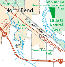
Little Si Natural Area
Little Si Natural Area contains significant habitat for a variety of fish and wildlife species. The Middle Fork of the Snoqualmie River supports a variety of non-anadromous fish, but Snoqualmie Falls downstream prevents anadromous fish from reaching the Middle Fork. The Middle Fork corridor is identified as a wildlife habitat corridor in the King County Comprehensive Plan (2004).
There is limited public use in the Little Si Natural Area, due to steep slopes and rocky outcrops that make the western flanks of Little Si Mountain virtually inaccessible. However, the proximity of the site to the Mount Si NRCA, and the presence of the "blue hole," a popular swimming hole adjacent to the site in the Middle Fork Snoqualmie River, ensure that the site is used by the public.
Little Si Natural Area is located at 436th Ave SE and SE 114th St, North Bend, WA 98045.
The Little Si Natural Area Site Management Guidelines are available in Adobe Acrobat format, in sections for faster download. For help using Acrobat files, please visit our Acrobat help page.