
 Translate
Neely Bridge Natural Arean
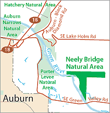
The King County Department of Natural of Natural Resources and Parks (DNRP) acquired Neely Bridge Natural Area from the Washington Parks Foundation for $10,500 in general county funds. In December 1977, Val Bain donated the property to the Washington Parks Foundation with the stipulation that the land be used as a public recreation area.
The Middle Green River supports populations of coho, chinook, and chum salmon, steelhead, rainbow, and resident and sea-run cutthroat trout. Bull trout have also been observed. The King County Wildlife Habitat Network runs through the Green River Corridor at the Neely Bridge Natural Area.
Although the site is available for passive recreation activities such as walking, fishing or hiking, the site is not visited often due to a lack of physical or legal access. There is no parking at the site, and there is no legal access route to the site from public roads.
The Neely Bridge Natural Area Site Management Guidelines are available in Adobe Acrobat format. For help using Acrobat files, please visit our Acrobat help page.
Download Here:
Neely Bridge Natural Area Site Management Guidelines