We currently offer language translations on our site primarily through Google Translate. This helps visitors find and use information in the languages they speak, but the tool is not perfect. Automated translation may be inaccurate or errors may display on translated pages.
Google Translate is an external website. King County does not control the quality or accuracy of translated content.
The website is scheduled for maintenance today. There may be intermittent outages on the website during this time. We apologize for any inconvenience and thank you for your patience.
Ravensdale Retreat Natural Area consists of eight parcels (145 acres) located in the Rock Creek Valley in the Ravensdale area, approximately one mile east of Maple Valley and two miles north of Black Diamond. The Natural Area extends east along Kent-Kangley Road (SR 516) from the junction with SE Ravensdale Way, bounded on its southern side by railroad right-of-way.
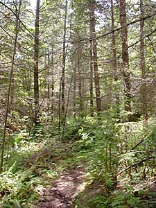
Most of the site is upland, supporting coniferous forest that was replanted following harvests during the 1980s, with interspersed upland deciduous species and small meadow patches. Ravensdale Retreat Natural Area also supports a two-acre pond/wetland complex, and other wetlands including wetlands adjacent to Rock Creek’s channel. Rock Creek flows through the site between River Mile 5.0 and 3.4. The wetland and riparian parts of the site include tree canopy of western red cedar, black cottonwood, and bigleaf maple, as well as scrub-shrub and emergent vegetation.
Ravensdale Retreat Natural Area supports trails that extend the length of the site, between SE Ravensdale Way and Ravensdale Park on the west side, and leading through the site to Kent-Kangley Road on the eastern side. The trails are regularly used for walking and horseback riding. There is parking available at Ravensdale Park, across SE Ravensdale Way from the site. There is no parking allowed at the gated road off of Kent-Kangley Road. Members of community stakeholder groups Backcountry Horsemen and Friends of Rock Creek Valley are key partners at the site, helping to maintain the trails and to control invasive species.
The Ravensdale Retreat Natural Area Site Management Guidelines are available in Adobe Acrobat format, in sections for faster download. For help using Acrobat files, please visit our Acrobat help page.
Download Here:
Ravensdale Retreat Natural Area Site Management Guidelines

 Translate