
 Translate
Ricardi Reach, Cedar Grove, and Jones Reach Natural Areas
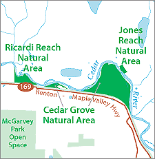 Ricardi Reach Natural Area, Cedar Grove Natural Area, and Jones Reach Natural Area contain adjacent properties along the Cedar River. These Natural Areas are located in the Ricardi and Jones Reaches of the Lower Cedar River, as identified through the Cedar River Legacy program which directs public conservation efforts in the Lower Cedar River. Ricardi Reach is located between RM 7.3 and RM 7.7; Jones Reach is located between RM 8.5 and RM 9.3.
The sites are located approximately 1-1/2 miles east of Renton's urban growth boundary, and are bounded by the Cedar River Trail and SR 169 to the south. These three Natural Areas contain nearly 1.25 miles of contiguous forested habitat along the Cedar River. The riparian forest and associated wetlands provide habitat for a variety of wildlife and bird species.
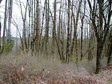
Cedar Grove Natural Area contains one 73-acre parcel of land on the left bank of the river between RM 9.3 and 7.8, also bounded by the Cedar River Trail to the south and meander bends of the Cedar River to the north. Cedar Grove Natural Area contains a 30-acre forested/scrub-shrub wetland, and the peninsula contains multiple side channels which convey river flow during times of high water. The parcel contains typical riparian red alder and black cottonwood forest, with a smaller proportion of coniferous trees and a dense shrub understory. There is no parking area (although drivers sometimes park on the highway shoulder at this site, WSDOT typically prohibits parking along state highway shoulders). There is one main access point on the west edge of Cedar Grove Natural Area, where a short informal trail extends from the Cedar River Trail to the water. This trail experiences regular use by pedestrians to view the river.
Jones Reach Natural Area contains just under 3 acres of land on the right bank, located at RM 8.9. Jones Reach Natural Area is bounded by Jones Road to the northeast and the Cedar River to the southwest. The parcel contained in Jones Road Natural Area is on the extremely steep (40% slopes in some places) north valley wall along the Cedar River. The steep slopes and lack of parking on the road shoulder limits safe public access to this site.
The Ricardi Reach Natural Area, Cedar Grove Natural Area, and Jones Reach Natural Area Site Management Guidelines are available in Adobe Acrobat format. For help using Acrobat files, please visit our Acrobat help page.
Download Here: