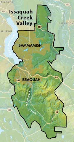
Issaquah Creek Valley Groundwater Management Area
This Groundwater Management Area encompasses ninety-three square miles located east and southeast of Lake Sammamish. The boundaries are defined by the drainage of Tibbetts Creek and Issaquah Creek watersheds and the water service area of Sammamish Plateau Water and Sewer District

Urban development is mostly concentrated in the cities of Issaquah, Sammamish and along the I-90 corridor. Outside of this urban area, the remainder of the management area is rural, characterized by low-density residential uses, forest and agricultural lands.
Almost all of the water used for private, municipal, and industrial and agricultural purposes in the Issaquah Creek Valley Groundwater Management Area is provided by groundwater sources.
ICV Groundwater Protection Committee —Inactive as of 2007
Groundwater Data
Issaquah Creek Valley Groundwater Management Plan
Issaquah Creek Valley Groundwater Maps and Reports
King County partnered with the City of Issaquah and Sammamish Plateau Water and Sewer District (external links) in these Groundwater Activities (2005-2007) within ICV GWMA:
- Hydrogeologic mapping within the Issaquah Creek Basin
- Exempt Well Assessment
- Groundwater Model of Upper Issaquah Creek Basin
Water Suppliers in Issaquah Creek Valley
This Groundwater Management Area has 22 Group A and 265 Group B Public Water Systems. The majority of the residents in this GWMA are serviced by the following Water Utility Service areas:
| Cedar River | KC Water District 127 |
| Edgehill | Mirrormont |
| Overdale | Issaquah |
| Four Lakes | Sammamish Plateau |
| KC Water District 90 |
This page is produced by the King County Groundwater Protection Program. To learn more about this group and its responsibilities, please read about the Groundwater Protection Program.

 Translate