
 Translate
Library and resources
Superfund Cleanup
|
Resources and website relating to the Lower Duwamish Waterway |
See the Lower Duwamish Waterway Group (LDWG) project library for a comprehensive listing of resources and websites relating to the Lower Duwamish Waterway. |
|
Lower Duwamish Waterway Source Control |
See the Lower Duwamish Waterway Group (LDWG) project library for documents produced under Administrative Order on Consent (AOC) with EPA and Ecology. |
King County's Early Action Reports
|
Duwamish/Diagonal Project |
Duwamish/Diagonal Project – removed 66,000 cubic yards of contaminated sediment from the Lower Duwamish. See Project Library for reports. |
|
Norfolk Project |
Norfolk Project – removed more than 5,000 cubic yards of contaminated sediment from the Lower Duwamish. See Project Library for reports. |
King County's Source Control Implementation
|
Lower Duwamish Waterway Source Control Implementation Plan |
King County’s Lower Duwamish Waterway Source Control Implementation Plans builds on over 50 years of investments made by King County to clean up the Duwamish River. The plans document ongoing and priority source control actions and programs, and the County’s coordinated source control efforts with external partners in support of LDW Superfund sediment cleanup. The plans offer information on the County’s continued commitment in the following areas:
2024-2028 Period This is the County’s third 5-year plan. It includes a summary of activities that the County is already committed to implementing through its CSO control plan, NPDES permits, and regulatory authority. As in our previous plans, the County has outlined additional source control actions that are not required by the CSO control plan or permits. In addition, this plan provides a review of the County’s source control actions implemented during the prior 5-year plan period (2019-2023).
2019-2023 Period
2014-2018 Period
|
|
Lower Duwamish Waterway Source Control Annual Reports |
Lower Duwamish Waterway Source Control Annual Reports. The annual reports document source control related activities conducted by the County per our LDW Source Control Implementation Plan. This includes source tracing data, summaries of business inspections, and source control actions within the County jurisdiction and authority. |
|
Lower Duwamish Waterway Source Control Fact Sheet |
Source control in Lower Duwamish cleanup, updated October 2020 |
King County's pollution source control studies and plans
|
Source Tracing in Combined Sewer System Sampling and Analysis Plan (Ongoing) |
Source Tracing in Combined Sewer System Sampling and Analysis Plan, August 2020. This sampling and analysis plan supports King County source control actions in the Lower Duwamish Waterway and East Waterway superfund sites. King County performs this work to help identify sources of chemicals of potential concern and as a line of evidence to be used in evaluating whether these chemicals are present in sufficient amounts to potentially recontaminate sediments in sediments near County CSO outfalls. |
|
Green River PCB Equipment Blank Study |
Green River PCB Equipment Blank Study Data Report, February 2018. This study aims to better understand the magnitude of sample equipment contamination bias associated with Green River water sample PCB results, as well as to determine which equipment components contribute to the contamination. Based on the findings of this study, two Green River surface water data reports have been revised to address the equipment contamination bias. Total PCB concentrations in these reports were adjusted to exclude the three PCB congeners (PCB-47, PCB-51, and PCB-68) affected by the standard silicone tubing used with the collection and processing of the water samples. This study indicates platinum-cured silicone tubing and Teflon tubing are acceptable for use in collection and processing of samples for low level PCB analysis.
|
| Lower Duwamish Waterway Source Control: Green River Watershed Surface Water Data Report (Revised 2018) |
Lower Duwamish Waterway Source Control: Green River Watershed Surface Water Data Report. This study measured surface water concentrations of arsenic, polycyclic aromatic hydrocarbons (PAHs) and polychlorinated biphenyls (PCBs) in samples collected in 2011 and 2012 from four major tributaries to the Green River (Newaukum, Soos and Mill creeks and the Black River), as well as at two locations on the main stem Green River: an upstream location at Flaming Geyser State Park (upriver of the tributary sampling sites), and a downstream location at Foster Links Golf Course (downstream of the tributaries).The objectives of this study were to: (1) better understand the relative contribution of arsenic, PAHs and PCBs to the LDW from upstream areas in the Green River and (2) evaluate the relative spatial differences between sampling sites and differences in dry season baseflow and wet season storm event conditions.
|
|
Lower Duwamish Waterway Source Control: Upper and Middle Green River Surface Water Data Report (Revised 2018) |
Lower Duwamish Waterway Source Control: Upper and Middle Green River Surface Water Data Report. This study measured surface water concentrations of arsenic, polycyclic aromatic hydrocarbons (PAHs) and polychlorinated biphenyls (PCBs) in samples collected in 2013 and 2014 from three sites: two were approximately 20 miles above the Howard Hanson Dam in the upper reach of the Green River; and one was below the Dam in the middle reach of the Green River at Kanaskat-Palmer State Park. The objectives of this study were to: (1) better understand the relative contribution of arsenic, PAHs and PCBs to the lower reaches of the Green River as well as LDW from upper and middle reaches of the Green River; and (2) evaluate the relative spatial differences between sampling sites and differences in dry season baseflow and wet season storm event conditions.
|
|
Lower Duwamish Waterway Source Control Michigan Combined Sewer Basin Study Data Report, November 2017. |
Lower Duwamish Waterway Source Control Michigan Combined Sewer Basin Study Data Report, November 2017. This data report presents the results of a study conducted within the South Michigan Combined Sewer Basin, which can discharge to the Lower Duwamish Waterway during substantial rainstorms. Combined sewer basins include inputs from domestic and industrial wastewater (sewage), groundwater infiltration into combined sewer lines, and stormwater. This study was a follow-up study to the Brandon Combined Sewer Basin Pilot Study. Both studies look at how much pollution is entering each combined sewer basin pipes during a rainstorm, and asks does it primarily come from sewage, stormwater, or groundwater? The results of this study are intended to be useful in guiding any basin-wide source tracing efforts in combined basins prior to CSO control. |
|
Lower Duwamish Waterway Source Control Brandon Combined Sewer Basin Study Data Report, May 2016. |
Lower Duwamish Waterway Source Control Brandon Combined Sewer Basin Study Data Report, May 2016. This data report presents the results of a pilot study conducted within the Brandon Combined Sewer Basin, which can discharge to the Lower Duwamish Waterway during substantial rainstorms. Combined sewer basins include inputs from domestic and industrial wastewater (sewage), groundwater infiltration into combined sewer lines, and stormwater. This pilot study looked at how much pollution is entering the Brandon Combined Sewer Basin pipes during a rainstorm, and asks does it primarily come from sewage, stormwater, or groundwater? The results of this study are intended to be useful in guiding any basin-wide source tracing efforts in combined basins prior to CSO control.
Lower Duwamish Waterway Source Control Brandon Combined Sewer Basin Study Sampling and Analysis Plan, August 2011 |
|
Duwamish River Basin Combined Sewer Overflow Data Report for Samples Collected from September 2007 to January 2010 |
Duwamish River Basin Combined Sewer Overflow Data Report for Samples Collected from September 2007 to January 2010.
Duwamish River Basin, Combined Sewer Overflow Survey, Sampling and Analysis Plan, October 2007, Draft |
|
Lower Duwamish Waterway Source Control: Supplemental Bulk Atmospheric Deposition Study Final Data Report |
Lower Duwamish Waterway Source Control: Supplemental Bulk Atmospheric Deposition Study Final Data Report. This study supplements the previous bulk air deposition study by collecting additional measurements of chemical air deposition in the Duwamish River Valley and on Beacon Hill in Seattle. A station in Georgetown was added and more samples for PCB and dioxin/furan congener analyses were collected to increase statistical power. Combined data from the main and supplemental studies were analyzed in this report.
Lower Duwamish Waterway Bulk Atmospheric Deposition Study Sampling and Analysis Plan - 2013 Addendum, April 2013 |
|
Lower Duwamish Waterway Source Control: Bulk Atmospheric Deposition Study Final Data Report |
Lower Duwamish Waterway Source Control: Bulk Atmospheric Deposition Study Final Data Report. This study measured bulk (dry particulate and rainfall) air deposition of chemicals of potential concern at locations in the Green/Duwamish Watershed during 2011 and 2012. The objectives of this study were to measure bulk air deposition in areas of different land use and development density, and to further understanding of atmospheric deposition sources to the Lower Duwamish Waterway.
Lower Duwamish Waterway Bulk Atmospheric Deposition Study Sampling and Analysis Plan, August 2011 |
|
Lower Duwamish Waterway Source Control: Green River Watershed Suspended Solids Data Report |
Lower Duwamish Waterway Source Control: Green River Watershed Suspended Solids Data Report: This study characterizes chemical concentrations in suspended solids and the differences of suspended solids quality between major tributary basins and the Green River during both dry conditions and wet season/storm events. The study focuses on key contaminants of concern for the Lower Duwamish Waterway Superfund site: arsenic, polycyclic aromatic hydrocarbons (PAHs), polychlorinated biphenyls (PCBs), and dioxins/furans. While this study does not estimate contaminant loading to the Lower Duwamish Waterway, the data can be used to help characterize the contaminants transported from the Green River to the Lower Duwamish Waterway. The results can also be used to help guide source control efforts; for example, identification of basins with elevated contaminant concentrations.
Green River Study: Suspended Solids Characterization Sampling and Analysis Plan: January 2013 |
|
Sediment Quality in the Green River Watershed |
Sediment Quality in the Green River Watershed. This study measured chemical concentrations in stream sediments in the Green River Watershed. The objectives of this study were to characterize chemical concentrations in stream sediments and to better understand the relative differences of sediment quality between tributary basins and the Green River. The sediment data will also provide information to assist in understanding upstream sources of chemicals to the Lower Duwamish Waterway.
|
|
King County Atmospheric Deposition Sampling 2005-07 |
King County Atmospheric Deposition Sampling 2005-07 (PAHs; PCBs; Phthalates) |
|
King County Sampling (Phthalates; Benzyl Alcohol) 2003-06 |
King County Sampling 2003-06 (Phthalates; Benzyl Alcohol)
|
|
King County International Airport Sampling 2006 |
King County International Airport Sampling 2006 (PAHs, PCBs, Phthalates, metals) |
|
Phthalate studies |
Phthalate Source Study, 2003 - 2005
King County participation, Sediment Phthalates Work Group (2007-08): The cities of Tacoma and Seattle, King County, Ecology, and U.S. Environmental Protection Agency work together to better understand how phthalates are reaching Puget Sound sediments and what are the related impacts to humans and animals. The work group evaluated existing information regarding phthalate sediment concentrations, identify data gaps, and recommend possible short-term actions. It also described possible ways to address long-term issues. |
|
King County and Seattle Public Utilities Source Control Progress Reports, 2004-05 |
These progress reports describe the status of source control activities completed by King County and Seattle Public Utilities as part of the Lower Duwamish Waterway Superfund cleanup. |
Miscellaneous studies and public outreach
|
Economic studies |
Estimates of Economic Impacts of Clean-up Activities Associated with the Lower Duwamish Superfund, November 29, 2010 |
|
Traffic and emissions studies |
Estimated Emission Reduction from Reduced Truck Transportation in the Lower Duwamish Waterway Corridor and Use of Lower Sulfur Fuels , January 14, 2014 Lower Duwamish Waterway Cleanup Project, January 10, 2014 Lower Duwamish Waterway Cleanup – Transportation and Emissions Studies, June 2014 |
|
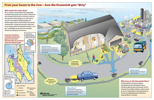
From your house to the river - how the Duwamish gets "dirty" |
From your house to the river - how the Duwamish gets "dirty", August 2009 |
Glossary
|
Air deposition |
Contamination entering a site by being carried on the wind as dust. |
|
AOPC |
Area of Potential Concern - where remediation efforts will occur within a Superfund cleanup. |
|
ARAR |
“Legally applicable or relevant and appropriate standard, requirement, criteria or limitation” promulgated under federal or state environmental laws. |
|
Background |
The contamination level at a site that cannot be removed due to its continuing existence in the environment. Waterways and sediments in urban areas have higher background contamination levels, called “urban background” than do undeveloped areas. Undeveloped areas have lower levels of contamination referred to as “natural background”. |
|
“C” Alternatives |
Alternatives within the Lower Duwamish Feasibility Study that focus on “Containment” of contamination through capping. “C” alternatives increase the seafood consumption risk, have longer construction periods and higher impacts for the community than do “C” alternatives. |
|
Capping |
Physically and/or chemically containing sediments in place. Achieved by placing clean sand, gravel or rock above contaminated sediments. |
|
COC |
Chemical of Concern – the chemical contaminants that trigger a cleanup and are monitored to evaluate the effectiveness of a cleanup |
|
CSL |
Cleanup Screening Level (MTCA term; only minor adverse effects from sediment remain when achieved) |
|
Dredging |
The physical removal of contaminated sediments from a waterway. Dredging projects increase and prolong the risk to human health from seafood consumption by stirring up contaminated sediments that are left behind during the dredging process and then consumed by fish. |
|
EAA |
Early Action Area – specific sites within the Lower Duwamish Waterway cleanup area that the LDWG partners (King County, City of Seattle, Port of Seattle, The Boeing Company) agreed to clean up prior to the Superfund listing. These projects serve as the basis for every cleanup alternative proposed in the Feasibility Study. |
|
ENR |
Enhanced Natural Recovery- encouraging natural processes that reduce health risks from contamination, typically by placing thin layers of clean materials on top of contaminated areas. |
|
ICs |
Institutional Controls – nonengineered methods for reducing the risk from a Superfund site’s contamination, such as seafood consumption advisories or beach closures.
|
|
MNR |
Monitored Natural Recovery – tracking natural processes’ reduction of health risks from contamination |
|
PRP |
Potentially Responsible Party – those entities the U.S. EPA believes to be responsible for the contamination at a Superfund site. There are more than 100 PRPs associated with the Lower Duwamish cleanup, including King County. |
|
PRG |
Preliminary Remediation Goal – The level of chemicals of concern necessary to attain to achieve the cleanup’s risk reduction goals |
|
“R” Alternatives |
Alternatives within the Lower Duwamish Feasibility Study that focus on “Removal” of contamination by dredging. “R” alternatives increase the seafood consumption risk, have longer construction periods and higher impacts for the community than do “C” alternatives. |
|
RAL |
Remedial Action Level - The chemical of concern level triggering remediation at a Superfund site. |
|
RAO |
Remedial Action Objectives – The cleanup’s risk reduction goals |
|
ROD |
Record of Decision – The U.S. EPA’s formal announcement of its decision on how to clean up a Superfund site. |
|
SMA |
Sediment Management Area – The area likely to be cleaned up during a Superfund. |
|
SMS |
Sediment Management Standards – The cleanup’s criteria including Sediment Quality Standards and Cleanup Screening Levels |
|
SQS |
Sediment Quality Standards - more stringent than a CSL. All risk to biological resources or humans from sediment are removed at this level |
|
SWAC |
Surface Weighted Average Concentration- Post-cleanup sediment concentrations, in this case describe the average PCB sediment concentration in the Lower Duwamish cleanup site. |
|
VM |
Verification Monitoring |