
 Translate
Redmond-Bear Creek Valley Groundwater Management Area
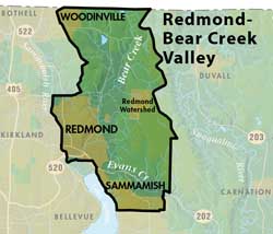
This Groundwater Management Area encompasses forty-four square miles located north of Lake Sammamish. These boundaries are from the Snohomish -King County border to the water service are of Sammamish Plateau Water and Sewer District. It is bounded on the west by the Sammamish River and on the east by the surface water divide between Bear Creek and Snohomish River valleys.
The focus of the residential, commercial and industrial land uses are within the cities of Redmond and Woodinville. The remainder of the management area has predominantly low density residential and neighborhood oriented commercial land uses.
The majority of the water used for private, municipal, and industrial and agricultural purposes in the Redmond-Bear Creek Valley Groundwater Management Area is provided by groundwater sources.
RBC Groundwater Protection Committee —Inactive as of 2007
Groundwater data
Redmond-Bear Creek Valley Groundwater Management Plan
Redmond-Bear Creek Valley Groundwater Maps and Reports
King County partnered with the cities of Redmond and Woodinville (external links) in these Groundwater Activities (2005-2007) within RBCV GWMA:
- Surface Water / Groundwater Interaction Study
- Additional support provided by a KCD Grant and Water Tenders.
- Geologic and Susceptibility Mapping
- Groundwater Educators Forum
Water Suppliers in Redmond-Bear Creek Valley
This Groundwater Management Area has 5 Group A and 107 Group B Public Water Systems. The majority of the residents in this GWMA are serviced by the following Water Utility Service areas:
Northeast Sammamish
Redmond
Union Hill
Woodinville
This page is produced by the King County Groundwater Protection Program. To learn more about this group and its responsibilities, please read about the Groundwater Protection Program.