Translate
Historical Building, Property, and Land Use Records
King County Archives holds records from as early as 1853 that document the interactions of King County government and its citizens with the natural world.
These records document aspects of the natural environment, including topography, landforms, bodies of water, and natural resources. They also document aspects of the built environment, such as residences and other structures, businesses and farms, transportation routes and systems, utilities, managed waterways, and recreational sites. Record types include maps and drawings, photographs, and textual records.
King County Archives holds maps, plans, drawings, and other graphical materials that were created by county agencies in the course of carrying out functional government responsibilities such as zoning and road establishments.
These records may be used for purposes not intended by their creators. Maps document neighborhoods, businesses, railroads and transportation corridors; changes in the environment, styles of building, and land use; and former King County facilities and structures such as wharves, gravel bunkers, and the Kingdome stadium.
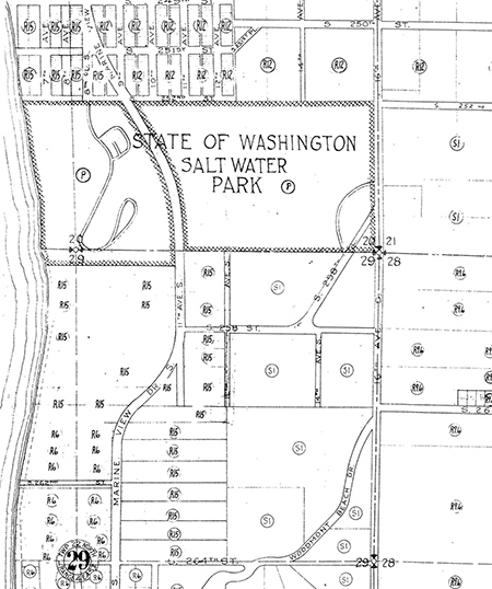
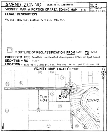
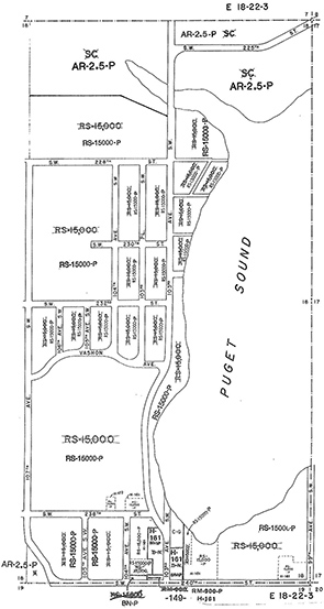
Land Use and Environment Maps
Graphical materials in the King County Archives document topics such as community planning , Donation Land Claims, drainage, erosion control, farmland preservation, land use, plats, river levees, tidelands and shorelands, topography, and zoning.
Environmental maps can also be found in published environmental impact statements, and in reports and studies of the Department of Natural Resources and Parks and the Water and Land Resources Division.
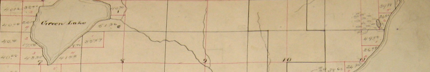
Donation land claim map showing Green Lake, Lake Union, and part of Lake Washington. (click image to open a larger version)
Under the Oregon Donation Land Act of 1850, Congress allowed 320 acres of land in Western territories to be claimed by a single person and 640 acres by a married couple. The claimants received final title to the land when they had lived on it four years and made certain improvements, or when they purchased their lands in lieu of fulfilling residency requirements. This volume of maps shows donation land claims, and other subsequent property holdings, in King County. The volume (probably a transcription, circa 1882, of U.S. Surveyor General maps) is a small (16 inches by 14 inches) bound blank folio into which thirty-six township maps have been drawn. Initial cartography utilized colored inks and a colored wash; later annotations were made in pencil. Each donation land claim is outlined in black ink and contains, as record information, owner name, acreage, claim number, and notification number. Coal lands and "cash entries" (claimant had purchased the land) are noted. Names and numbers correspond with ledger entries in Series 341, Field Survey Notes: Donation Land Claims (1882). In addition to property holdings, maps show watercourses (streams, springs, ponds, lakes); prairies and wetlands; resources (coal deposits, cranberry bogs); structures (roads, trails, wagon roads, school); and Native American villages and reservations. The volume is arranged in ascending numerical order by range (numbers 2-6) and within each range, by township (numbers 21-26).

Hand-colored topographical map showing part of drainage district 10 in Snoqualmie River Valley near Duvall, circa 1920. (click image to open a larger version)
The 1895 Washington State legislature authorized counties to establish diking and drainage districts. These districts, formed by citizen petition, were authorized to sell bonds and levy tax assessments to raise funds for flood control measures within the districts.
Part of the documentation prepared by King County drainage districts included topographic maps of the area covered by the districts. This series includes topographic maps of drainage districts 8 (White [Stuck] River near Algona-Pacific City), 9 (Sammamish River near Kenmore-Hollywood), 10 (Snoqualmie River near Duvall) and 11 (Green River near Auburn). The maps show fence lines, roads, drainage ditches and streams, as well as buildings. Proper names or other reference points rarely appear on these maps. Scale 1" = 200'.
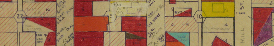
Map of Renton area businesses and land usage, circa 1960s. (click image to open a larger version)
During its existence (1959-1972) the King County Planning Department maintained a research section responsible for collecting, maintaining and analyzing various forms of planning data used to create and update the county's Comprehensive Plan. The maps in this series were maintained as an ongoing record of land use in King County.
Base maps, of half- or quarter-sections at a scale of 1" = 100' or 1"= 200', were acquired from various sources. Principal were the commercial Kroll Map Company, for urban areas, and the King County Assessor's Office, for rural areas not mapped by Kroll. Some maps, of more remote areas, were drawn by Planning Department staff.
Most base maps were blueline reproductions. On each map, the location of buildings on their sites was rendered in colored ink outlined in pencil. Some additions to the base maps were made on tracing paper or mylar overlays which accompany the maps. Type of structure, or nature of its usage (for example, type of business) was indicated. Also indicated were types of unbuilt natural environments (for example, woods or fields), and of non-structural land usages (for example, junk yards or agricultural croplands).
The 1626 individual maps have been organized into 22 rolls. The rolls are arranged in two ways. Rolls 1-17 are organized by ascending three-digit Kroll map numbers, which correspond to specific section numbers within townships and ranges (key available in series file). Rolls 18-22 are organized generally by range and then by township.
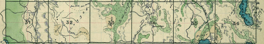
Timber cruise map of Section 25, Township 23, Range 5, showing Echo Lake (Lake Desire) area, 1907. (click image to open a larger version)
Washington State counties consider standing timber as real property for the purposes of taxation. During the period 1907-1967, the King County Assessor's Office undertook forest surveys, or timber cruises, to locate and estimate the quantity and taxable value of timber in a given section of land. Only land sections containing appreciable amounts of harvestable timber were surveyed.
Survey information was maintained in small ledgers or notebooks. Over time, the amount and detail of recorded information varied. Later records do not include the level of detail earlier ones. During the period 1907-1936, for each section represented , there are usually general remarks about the section as a whole, and detail descriptions of its forty-acre (quarter) tracts.
Timber data includes information such as the species and quality of timber growing on the land, a visual calculation of its board footage, the age of the timber, the costs of logging (determined by such things as nearness to market, topography, accessibility, etc.), and possible wood products. For each section, surveyors also noted, under the heading "Improvements," additions to the built environment (structures, agricultural plantings and field clearings, equipment and vehicles, etc.
Property owner names are generally stated when known. Textual information for each section is accompanied by a small (4" x 4") hand-drawn or -colored map. The section maps show topography; natural features (rivers, mountains, swamps, lakes); condition of land (burnt, cleared, plowed, cultivated); transportation infrastructure (roads, trails, mainline and logging railroads); structures (houses, sheds, barns); businesses and industries, and other features (water tanks, cemeteries, coal bunkers, etc.)
Road, Trail, and Utility Maps
Holdings of the King County Archives include graphical materials which provide locations or construction details of infrastructure such as roads, bridges, wharves and ferry landings, mainline and logging railroads, and streetcar rights-of-way; hiking, pedestrian and equestrian trails; fire, sewer and water districts; electricity transmission lines, and sewer system maps. Maps and plans can be either generated by King County agencies or acquired by them (for example, from railway companies or from housing developers).
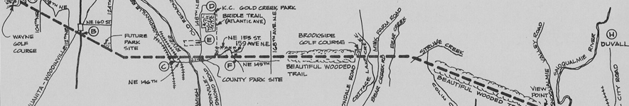
Tolt Pipeline Trail map from a King County Parks brochure, circa 1974. (click image to open a larger version)
The Tolt Pipeline Trail was established under the 1968 Forward Thrust bond issue. It follows a City of Seattle Water Department pipeline right-of-way. This map, part of a brochure (c. 1974) describing the trail, is part of a folder of background information relating to various county trails that was kept by the director of the Department of Planning and Community Development. This department was established in 1976 and succeeded the Department of Community and Environmental Development. Its functions included overseeing community planning and development processes, coordinating local and national housing assistance projects, and monitoring land use and regulatory codes. The department was succeeded by the Department of Parks, Planning and Resources in 1986.
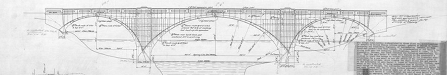
Design drawing for three-arch concrete highway bridge (#3036) over the Green River at Kanaskat, 1915. (click image to open a larger version)
King County, through its public works agencies, has been historically responsible for the siting, construction, inspection, maintenance, repair and replacement of highway bridges, overcrossings, and undercrossings within its jurisdiction. The county maintains a record of these activities for each bridge. Part of this record is maps and drawings. This series is composed of oversized site and vicinity maps; structural plans; standard detail drawings; and field and survey sketches separated from Series 36, Road Engineer Bridge Files 1901-1994.
In general, graphic materials measuring 8.5 by 14 inches or less have been retained in Series 36. The oversized graphic materials in this series are present in various physical formats, primarily reproductions using various processes (blueprint, blueline, brownline, xerographic). Field sketches may be original pencil or ink drawings on paper.
A preliminary division of the oversized maps and drawing has been made, according to their storage status (folded in document boxes, or unfolded in map drawers) has been made. Within each group, maps have been given a temporary ascending numerical arrangement corresponding to the box and folder in Series 36 from which they were separated. Related records: Accessions from the Roads Map Vault of the King County Department of Transportation may contain original versions of reproduced drawings found in this series.
Washington State allows counties to grant franchises to corporations to use and occupy public streets, roads, rights of way and public places over which a county exercises its jurisdiction.
These records document individual utility and transportation franchises issued by King County between 1898 and 1988 to private companies (railroad, streetcar, gas, electric power, water, and cable television companies); water and sewer districts; federal agencies (Bonneville Power Administration; Civil Aeronautics Board); and local municipal governments. Franchise file documents vary over time but generally include a letter of application, a legal description of the proposed franchise, and records of the county's response. Additional correspondence may be present. Maps accompany most text records and may be either annotated copies of commercial or plat maps, or original maps created by the applicant.
The franchise files have been organized into three subseries based on the manner in which they were filed over time: by Auditor's file number, by county franchise number, and by legislative file (resolution, ordinance or motion) number.
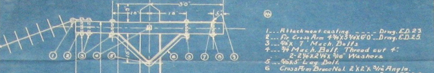
Electricity transmission tower, Milwaukee Road railroad, 1915. (click image to open a larger version)
Franchises arranged by Auditor's file number (1898-1915)
After 1901, Washington counties were permitted to issue franchises outside of incorporated cities and towns for electric railways and streetcar lines; to water and gas companies; and for electric power, telephone and telegraph transmission lines ("pole lines"). This subseries contains franchises for various street and interurban railway companies, notably the Puget Sound Traction, Light and Power Company; the Seattle Electric Railway Company; and the Highland Park and Lake Burien Railway. It also contains franchises for railroad over- and undercrossings, telephone and electric power lines, and water mains. The franchises are arranged in ascending numerical order by the official file number given to public records by the County Auditor, who served as the clerk of the Board of County Commissioners.
Franchises arranged by county franchise number (1916-1969)
In 1916, King County established new recordkeeping practices. Franchises were maintained in their own ascending numerical sequence (1-620) and were physically housed with the County Engineer as part of that office's right-of-way department. From 1916 to 1945, the majority of franchises issued were for electric power transmission lines. After 1945, numerous franchises to water companies and water and sewer districts reflect post-World War II housing construction. Television cable franchises are present in the files for the 1960s.
Franchises arranged by legislative file number (ordinances and motions; 1969-1988)
Following King County's adoption of its home rule charter in 1969, franchises were maintained in relation to, and by the same file number as, the County Council ordinance or motion which authorized them.
Most plat maps have been recorded by the King County Auditor (1853-1969) and the King County Recorder's Office (1969-present). Unofficial images of all recorded plat maps are indexed and available on the King County Recorder's Office website.
Original copies of most recorded plats are available for research at the King County Archives.
The Map Vault of the King County Road Services Division can often provide researchers with electronic versions of many plat maps and recorded binding site plans.
Additional search tips for recorded plats can be found on the Recorded Documents research guide.
Plats are accepted, established and modified by the King County Council (prior to 1969, the King County Commissioners). To find the actual Council ordinance or Commissioner resolution establishing or modifying a specific plat, see the county's Legislative Files or contact the King County Archives.
Additional information about the establishment or modification of plats, pre-1969, can be found in the Commissioners' plat application files (1916-1970). These applications were submitted for the final approval of a plat by the Commissioners. Individual files typically contain a certificate prepared by an attorney indicating that the ownership of the property and the payment of taxes have been verified, along with the recommendations from the office of the County Engineer. A small number of the files contain plat maps. The files are arranged by an office filing number.
A plat vacation is an action, taken under Washington state law (RCW 58.17.212) but handled by local governments (in King County by the County Council), that removes the dedication* (to general or public use) from a recorded plat or a portion of the plat and returns the property to private ownership.
Plats, and platted road and street rights-of-way, are vacated by the King County Council. To find the actual Council ordinance see the county's Legislative Files or contact the King County Archives.
Plat vacations prior to 1969 were sometimes made by resolutions of the King County Commissioners. More often they were made by direct orders of the Commissioners. Texts of plat vacation orders can be found in the Commissioners' Proceedings or in their plat vacation files. These files are arranged by vacation order number (5024 to 8464). They also include supporting documentation such as petitions, maps, engineers' reports and correspondence. For assistance in locating a plat vacation order, please contact the King County Archives. It is helpful if you have a date, or an approximate date, of the plat vacation.
* A dedication is the deliberate conveyance of land by an owner for any general and public uses, reserving no rights other than those that are compatible with the full exercise and enjoyment of public uses for which the property has been conveyed. Dedications are made by the property owner filing a final plat, short plat, binding site plan, or quitclaim deed.
Sometimes old documents and maps will refer to an "unrecorded plat." Prior to 1948, some King County plats were unrecorded. Commissioners' Resolution 11048 (March 23, 1948) changed all existing unrecorded plats to "preliminary plats." Preliminary plats were generally finalized after an accurate survey was undertaken and approved. For assistance in associating a former "unrecorded plat" with a past or current tax parcel, please contact the King County Department of Assessments.
Short Plats
Search tips for recorded short plats can be found on the Recorded Documents research guide.
Surveys
Search tips for recorded surveys can be found on the Recorded Documents research guide.
Aerial Photographs
For information about aerial photographs held by King County Archives, visit the Historical Photographs research guide.
King County Archives holds original and reproduction drawings of many former and existing county structures. Degree of detail may vary (full architectural or structural drawings, elevations, sections and detail drawings; or just simple site plans or outline sketches). Some structures represented in these collections are: Boeing Field structures; bridges; county maintenance shops and other facilities; health and social services facilities; hospitals; juvenile detention facilities; King County Administration Building; King County Courthouse (formerly, County-City Building); the Kingdome stadium; park and recreational structures; sand and gravel bunkers; warehouses; and wharves, docks, and ferry passenger waiting rooms and shelters.
King County Archives holds original and reproduction drawings of many former and existing county structures. Degree of detail may vary from full architectural or structural drawings, elevations, sections, and detail drawings to simple site plans or outline sketches. Some structures represented in these collections are:
Series 483: Boeing Field records
This series consists of maps, plans and other graphical materials that visually represent the infrastructure of the King County International Airport (Boeing Field) from the time of its construction (1929) to 1999. They were brought together as a group by the King County Department of Transportation in 2002 in response to potential litigation involving the cleanup of the Duwamish River. As part of this process the record items were professionally conserved and digitized.
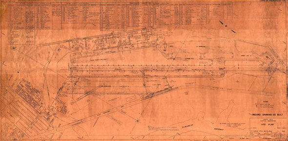
War Department map showing placement of National Youth Administration (NYA) structures at Boeing Field at the beginning of World War II, 1941. The NYA was a federal job-training program emphasizing defense-related skills. (click image to open a larger version)
Types of graphical material in this series include: master site and layout plans , including maps showing utilization of Boeing Field by the United States military during World War II; maps of owned and leased airport property, including maps of specific property acquisitions and demolitions; utility maps (air, electrical, fire systems, lights, plumbing); sanitary and storm sewers, storm drains and pump stations; plans of structures of the King County International Airport (passenger facilities, hangars, ancillary structures, airport lessees' structures); plans of Boeing Company structures located at the airport; maps of fuel tank locations; environmental inventories and maps and plans relating to water pollution control programs.
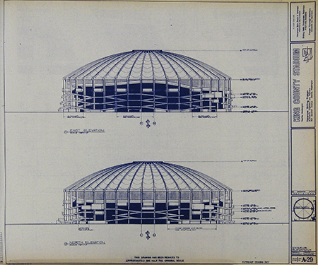
Side elevation of Kingdome covered stadium, Seattle, 1972. (click image to open a larger version)
Series 497: Kingdome architectural records
These architectural records were collected and maintained by the Department of Stadium Administration's Maintenance Section. Documenting the Kingdome as a physical structure, one that was a subject of controversy and litigation later in its life, the records consist of project and subject files, and plans and drawings. Major topics represented include baseball field expansion; ceiling repair; consultant reports; documents relating to original Kingdome construction (construction specifications and other documents, mylar drawings of design and structure); executive suite design and construction; landscaping; maintenance office and shop expansion; miscellaneous studies; modifications for executive suites and roof renovation; pre-Kingdome stadium proposals; and specific project files (concession areas, day care facility, railing caps, seating additions, sprinkler system).
Road Services Division records
King County Archives holds original records created by the King County Road Services Division and its predecessors. These records include aerial photographs; historical survey data; building plans; and a variety of specialized maps (assessor, bridge, drainage, engineering, erosion control, establishment, maintenance, parks, right-of-way, roads, structure, survey, topographical and traffic). They also contain supporting documentation about the establishment, construction and maintenance of county roads and bridges, and of other county structures and facilities which are, or have been, the responsibility of the division or its functional predecessors.
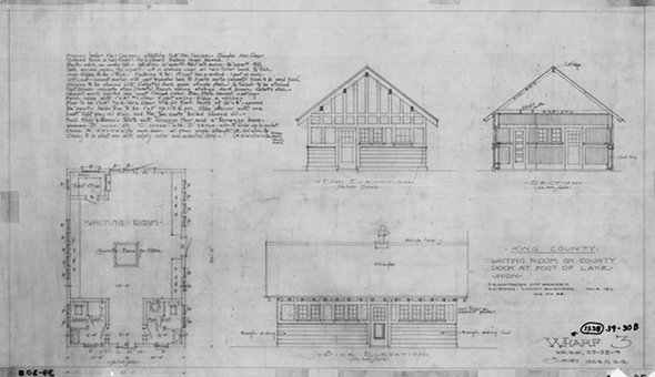
Floor plan and elevations of waiting room for King County's Prospect Street Wharf on southeast Lake Union, Seattle, 1917. (click image to open a larger version)
King County Road Services Division maintains digitized copies of the originals held by the Archives, and makes them available online on the Map Vault. The King County Road Services Division's Map and Records Center also retains physical custody of some of the older supporting documentation relating to county roads. Digitized records available on the Map Vault include:
- Boeing Field structures
- Bridges
- County maintenance shops and other facilities
- Health and social services facilities at Georgetown, south Seattle (indigent shelter, tuberculosis hospital, crematorium)
- Hospitals
- Juvenile detention facilities
- Park and recreational structures
- Sand and gravel bunkers
- Schools
- Wharves, docks, and ferry passenger waiting rooms and shelters
Series 36: Bridge files
These files constitute a record of highway bridges built by, transferred to, or eliminated by King County between 1901 and 1994.
Series 1306: Construction project files
This series contains a blueprint of the King County Courthouse (formerly the County-City Building).
Additional Records
Puget Sound Regional Archives in Bellevue holds building plans created by King County's former Building and Land Development (BALD) Division. An inventory of these records is available.
Terminology
The Uniform Commercial Code (UCC) is a set of laws that govern commercial transactions such as sales, warranties, negotiable instruments, loans secured by personal property, and other commercial matters. The UCC has been adopted in some form in every state. In 1965, Washington State first adopted RCW 62A.9A (effective July 1, 1967).
Properties in unincorporated King County
The King County Permitting Divison holds the following building plan records:
- Residential buildings, 1987-present (some plans may be available from 1970)
- Commercial buildings, 1970-present
Properties in the city of Seattle
The Seattle Department of Construction and Inspections holds the following building plan records:
- Single-family residential buildings, 1974 - present
- Commercial and multi-family residential buildings, 1974 - present
(Some microfilm plans exist for structures dating back to the late 1800s and early 1900s.)
Properties in other incorporated areas
The King County Archives also holds the following records from the 1960s. Most of the plans are outline sketches of basements or other protected areas:
Series 409: Seattle-King County Office of Civil Defense fallout shelter records, 1962-1968
During the Cold War era of the mid-twentieth century, national, state and local governments cooperated in identifying and preparing spaces in public and residential buildings which could be used as shelter in case of a nuclear attack. The Seattle-King County Office of Civil Defense served as the local government liaison with state and federal civil defense agencies.
The records in this series are copies of state and federal documents prepared using local data, and returned to local authorities for their reference and use. They consist of records of the National Fallout Survey (Phases 1 and 2), and additional facility sketches and state reports. Record information from Phase 1 (1962) shows area population; shelter capacity; and total buildings; shelter location; identification information; use if any as a school; owner; physical vulnerability to nuclear attack; year built; survey method; and protection factor code. Phase 2 (1968) record information includes name of structure and address; identification information; number of stories; existing spaces; assessment of shielding, ventilation, and electrical power needs and sources; shelter dimensions; average mass; and distance to center of shelter from its peripheries.
These records are arranged by facility number (FN). Additional records, 1967-1968, include photocopied shelter floor plans, plus records for "non-qualified" buildings; and computer printouts. Record information may include the name and address of shelter, identification information, protection factor, amount of space, ventilation improvements needed, license date, and stocked spaces (i.e., with survival supplies). Contact the King County Archives for information regarding these records, or to schedule a viewing appointment.
King County Assessor's Real Property Record Cards
Puget Sound Regional Archives in Bellevue holds the Real Property Record Cards, which may contain a small sketch of the exterior plan of buildings including dimensions. The cards don't contain detailed floor plans or blueprints.
Architectural Drawings
The University of Washington Libraries, Special Collections Division maintains a collection of plans of buildings designed by local architects, dating from 1889 to the 1980s. Search this collection using their online search engine.
King County establishes and maintains streets, roads and bridges in unincorporated areas of King County. Historically, King County roads were initiated by citizen petition. The proposed route was reviewed ("viewed") by a group of citizens (later, by the County Surveyor or surveyors from the County Engineer's office). The road was then authorized or rejected by the county commissioners. If approved, the county could then undertake to acquire property for the right-of-way and to build the road.
At their establishment, roads were typically given a name (usually the name of the principal petitioner) and a number. Road names and numbers often changed over time. Also, roads were sometimes authorized but never built, or not built in the way that the establishment records described.
Visit King County Road Services' webpage for information about Capital Improvement Program projects. Visit King County Road Services Road Maintenance Services and FAQ webpage for information road maintenance.
County Sources of Records
King County Archives holds historical records, including County legislative files, that may be used to research establishment, construction and maintenance of present-day streets, roads, and bridges.
King County Road Services Division's Map and Records Center is responsible for maintaining maps, historical survey data, and other supporting documentation about the establishment, construction and maintenance of county roads and bridges, and of other county structures and facilities which are, or have been, the responsibility of the division or its functional predecessors. The records span the 1850s to the present. In addition to maps, these files also contain original text documents from the 1800s, usually handwritten, that were subsequently transcribed in the Road Books.
Digital Resources
The documents are available digitally through Road Services Division Map Vault. This online digital collection contains full-sized hard-copy maps (survey, route, vicinity, detail, plat, topographic) of historical and contemporary county road projects, indexed by map title, road name(s), section-township-range coordinates, map date, map type, and survey number. Please contact the Map and Record Center for more information about accessing the maps and other graphical materials available on the Map Vault. King County Archives holds the hard-copy, original records.
Non-County Sources of Records
King County may enter into construction and maintenance agreements with municipalities, utility taxing districts, or the Washington State Department of Transportation. These jurisdictions may hold additional street and road records of research interest. After 1910, the state of Washington increasingly shared responsibility for major roads within counties. Historical records of the state Department of Transportation and its predecessor, the state Highway Department, can be found at the Washington State Archives in Olympia.
In general, the King County Archives retains formal legal documents relating to road establishments and locations. The King County Recorder's Office is the principal source of right-of-way deeds. The Road Services Division's Map and Records Center holds historical engineering documents relating to technical aspects of building and maintaining a given road.
The best way to access records that may relate to a specific road is through one or more search categories. These can be one, or any combination, of the following:
- Approximate road establishment date
- Road name
- Road number
- Survey number
- Section-township-range coordinates
King County Archives staff can help you determine a search strategy that may help identify road histories in our record collections. These collections include:
King County Commissioners' proceedings, 1853-1969
King County Archives holds the original County Commissioners' proceedings. These records contain meeting minutes and transcribed resolutions, orders, and records of Commissioners' actions. The proceedings are indexed in 18 volumes, and each volume is organized into topical or functional sections. The following are all sections in the indexed proceedings that are related to roads.
- Roads: volumes 1-18, 1853-1969: Lists of road names and Commissioners' actions including bids called, advertised, ordered, accepted, and completed, as well as hearings that were set and referred to the County Engineer. For some entries, miscellaneous file, resolution, contract, or project numbers are present.
- Viewers of road: volume 1, 1853-1885: This index section refers to road petitions and appointments of non-professional residents to view, survey and lay out the road described in the petition.
- Road district overseers: volume 2, 1889-1901: This index section includes entries regarding election and appointment of, and petitions and bonds for, overseers of road districts. The overseer, also known as the road supervisor, was responsible for maintaining roads, collecting road poll taxes, and making regular reports to the Commissioners.
- Road districts: volume 3, 1901-1914: This index section includes entries relating to petitions for road districts, the formation of road districts, and appointments of supervisors for the districts.
- Road establishments: volumes 4-18, 1914-1969: This index section includes entries listing the name of the person or the road involved and the Commission action (for example, hearing set, road established).
- Petitions: volumes 5-18, 1921-1969: This index section includes listings about petitions for appointments, annexations, road and district improvements.
Note: Additional proceedings relating to road matters are recorded in volumes 3, 5, 7, and 9 of the King County Commissioners' Road Books.
King County Commissioners' road books, 1854-1900
Different types of record information may be found in a single road book. Road books are generally arranged chronologically. Portions of Road Books 3 and 6 index road information in the other volumes; these index sections are arranged by road number. Cross-references, to road number or to related volumes of Commissioners' Proceedings, have been hand-entered, usually in red pencil, in the chronological volumes. Road Book indexing is replicated and expanded by the two volumes in the Index to Road Records. Road establishment records after 1900 can be found in volume 2 of this series, the Commissioners' Road Files, and the Commissioners' Proceedings. For questions, or access to the Road Books, please contact the Archives.
The volumes in this series record county road establishments and other road matters undertaken by the King County Commissioners between 1854 and approximately 1900. Records are not present between August 1871 and February 1873. There are nine road books in eight volumes (Road Books 1 and 2 are bound together). The volumes contain five types of handwritten record information:
- Road data or "field notes" (road number, road width, section-township-range coordinates, survey lines and coordinates, and dates that actions were taken regarding a specific road).
- Transcriptions of essential documents relating to the establishment of roads (petitions, appointment of road viewers and road supervisors, road viewers' reports, surveyor's reports and certificates, transcriptions of affidavits and bonds, legal notices, establishment orders, orders for payments). Road Book 8 consists of transcribed official recordings arranged by Auditor number (1892-1900).
- Transcriptions of County Commissioners' proceedings having to do with road business of all types.
- Transcriptions of deeds for road rights-of-way (Road Book 7, 1892 only).
- Road plat maps (Road Book 4; with other maps incidentally in other volumes).
Commissioners' Road Files, 1899-1916
This series contains text documents relating to road establishment, construction and maintenance, arranged by auditor's filing number (roughly chronologically) and cross-indexed by road number. Route, vicinity and survey maps may be present for some roads.
Road deeds log, 1905-1909
This volume appears to be a ledger kept for the purpose of documenting King County's acquisition of property, by deed or condemnation, for road rights-of-way during this time period. Individual entries were made for each road. Record information usually includes road name, a short description of the road, and its width. Also present may be road number ("R#") or survey number ("S#"); essential dates (of road examination, survey, completion); and other handwritten notes. A second section details information about property owners: section-township-range coordinates of property, part of section affected, owner name, owner address or whereabouts, property price, acreage, and other remarks. Remarks usually state the date the property deed was received by King County. Also noted may be the status of the property acquisition, problems with individual owners, efforts to locate owners, condemnation activities, and the ultimate status of the road. Arrangement of the volume is roughly chronological. An alphabetical index to road names is present. There is no owner name index.
Engineer's road petition files, 1916-1935
This series contains documentation, retained by the County Engineer between approximately 1916 and 1935, relating to citizen road petitions. Records for each petition or road may include original signed petitions, maps (hand-drawn or annotated blueprint copies), and copies of Commissioner resolutions. Correspondence is also present, notably letter reports made by the county's Reconnaissance Engineer to the Commissioners. These reports, which are not present for every petition file, may provide information about county settlement and transportation patterns in a given area, as well as about road feasibility.
Most of the records are arranged alphabetically, by name of principal petitioner or by road name). Alphabetical filing order is approximate. Under each letter, records follow a chronological pattern. Each folder contains a photocopied agency list with the names of petitioners or roads which purport to be in that folder. A second, smaller group of records relate to petitions from Road District No. 2, comprising the southern portion of King County. These records are arranged chronologically (1929-1935).
Definition
A road vacation is an action taken by the King County Council (prior to May 1, 1969, by orders of the King County Commissioners) whereby the public interest in a road right-of-way* is removed. King County holds an easement on right of way for public travel on most streets and alleys outside of incorporated areas of the County. This interest may be terminated by the County ordinance if the easement is considered useless to the County's needs and deemed beneficial by the return of the unused area to the public tax tolls. RCW 36.87 and King County Code 14.40 govern the vacation of rights-of-way in King County.
Search for Records
To search digitized County Council ordinances authorizing the vacation, visit the King County Legislative Archives. King County Archives holds the physical ordinance files.
Prior to May 1969, road vacations in unincorporated King County were sometimes made by King County Commissioner resolutions. More often they were made by direct order of the Commissioners. Texts of road vacation orders can be found in the County Commissioners' Proceedings, which are held by King County Archives. The easiest way to search for a road vacation is by order number of the approximate date of the vacation.
Another source of information is the Commissioners' road vacation files, which are held by Puget Sound Regional Archives in Bellevue. These files are arranged by vacation order number (1 through 1413). The files usually contain the original signed road vacation order and may also include supporting documentation such as petitions, maps, engineers' reports and correspondence. Please contact the Regional Archives to access these records.
When unincorporated areas of King County incorporate into municipalities, the municipalities assume responsibility for road actions such as vacations. Your municipality's ordinance files may contain relevant information.
* A right-of-way is public land, property, or property interest (e.g., an easement), usually in a strip, as well as bridges, trestles, or other structures, acquired for or devoted to transportation purposes. This does not include recreational or nature trails except where they intersect with or are located within road rights-of-way. Rights-of-way are established through deeds or easements.
Unmaintained county right-of-way refers to a road within the county right-of-way that is accessible to public travel but is not maintained by King County.
King County's street naming and numbering system developed over the course of the twentieth century. It was aimed at developing a clear and concise street designation system intended to lend increased facility to the location of addresses. A numbered grid pattern of avenues and streets, an extension of and compromise with the City of Seattle's street system, is the centerpiece of the system.
The system had its beginning in 1920 and 1921 with the passage of two Commissioners' resolutions (690, 730) which extended the grid north and south from what were then the city limits of Seattle. The next surge followed in 1930 with the adoption of two more sizable resolutions (3709, 7558) which further extended the grid south and north of Seattle. Preference was given to numbered avenues and streets rather than named roads.
Resolution 16622 (August 13, 1956) extended the grid numbering system countywide and is considered the base legislation for all amending resolutions and ordinances that followed. This resolution authorized the use of numbers to replace names as often as possible.
Names were retained on some roads and some new names are still assigned. Names are used where they have meaningful geographical significance, or for roads that deviate too widely from the grid system to make numbers practical. A name is not retained or a new name is not assigned if a number designation fits the grid system.
King County Archives retains copies of all road name resolutions and ordinances in its legislative files. The road name changes are set out in the resolution or ordinance by section-township-range coordinates, and states the former and new name of each road.
The Archives also holds records relating to Vashon Island road name changes: Vashon-Maury Island street addressing, 1988-1991. To improve emergency response access to locations on Vashon and Maury Islands, in 1988, King County initiated a street measurement and address assignment project. The project, which changed most named streets to numbered ones. It was undertaken by a team of local residents under general direction of the Building and Land Development (BALD) Division.
The Vashon-Maury Island street addressing file consists of a manual and project history compiled at BALD's request by geodata technician Ken Brooks. The manual comprises text sections illustrated with copies of forms, worksheets, maps, correspondence, etc.; section topics include socio-cultural background and community information; measuring and recording fieldwork; road designations; address number assignment; map and sign preparation; quality checks; and project wrap-up. Two appendices include copies of Vashon/Maury Island newspaper articles, and photocopied snapshots of project participants.
Maps were generated in connection with the establishment or construction of King County roads. There are different types of road maps: engineering (design and construction), establishment, maintenance and paving, right-of-way, survey, or topographical. King County Archives holds the following historical road map records.
Commissioners' Road Book No. 4, 1876-1881
Road Book 4 consists of hand-drawn and hand-colored route maps, keyed to textual road establishment documents for that period. Access is by survey coordinates; some keyword access is available.
Plat reference maps, 1900-1950
These blueprint copies of plat maps were acquired and retained as a reference collection by the County Engineer's office. They are arranged in folio post-bound volumes by township and range. Annotations showing various public works projects and property actions have been penciled on the plat maps.
Survey books, circa 1901-1907
Between 1855 and 1907, the County Surveyor was required to execute any survey required by the county commissioners, or by any court, individual or corporation; after 1901 an index to the surveys was required to be kept.
This series consists four large volumes organized by King County range and township numbers, with one page allocated to each section within a township. On some section plans, survey lines have been marked, with relevant survey notes handwritten on the facing blank page. The surveys are of all types (for example, surveys to locate roads or lost section corners; surveys done for individuals; surveys to create lots within plats). There is a section-township-range index in each volume.
Engineer's preliminary topographic map books, 1908-1937
This series contains field maps and notes made by county surveyors documenting topography of proposed county projects. A number of surveys made at the request of individuals or groups are also present. The field maps and notes were drafts used to prepare formal survey maps. They consistently show elevations and contours along the route of, or at the site of, the proposed project. They may also contain more visual information about the natural environment (streams, vegetation, agricultural crops) and the built environment (structures, fence lines, routes of existing roads and old trains, bridges, skid roads) than is present in the perfected maps.
Other record information often present is surveyor names, survey number, survey date, and location of survey stations. They are arranged is by volume number in a roughly chronological sequence. One unnumbered volume from 1908 is present at the beginning of the series. Each volume may contain records of more than one project. An index page is present in most volumes.
Road establishment books, 1912-1936
This series is composed of bound atlases of master maps locating established county roads. Most atlases are arranged by section-township-range coordinates with each section represented by one map. Road numbers are usually present on the maps. Books in this series include:
- Road establishment atlas,"TxN RxE," approximately 1874-1909
- King County Highway Plat Book #1, 1890
- King County Engineer: Existing County Roads, 1912-1917
- Road establishment book, 1913
- King County Engineer road establishment atlas, ranges 5 and 6, 1931
- King County Engineer road establishment maps, ranges 7 and 8, 1930
State highway plans, 1925-1933
After 1900, Washington counties worked increasingly with the state Highway Department to maintain roads built with state funds. The Highway Department sent reference copies of its highway plans to the counties. These plans are for State Highway #1 (Pacific Highway, through Auburn, Kent, Des Moines, Seattle, and via North Trunk Highway to the Snohomish County line) and State Highway #2 (Sunset Highway, over Snoqualmie Pass).
Volume 1 is for grading both highways, and there is one volume each per highway for concrete paving. In addition to construction details, the plans provide information about the land to either side of the right-of-way: property owner's names, location of structures such as barns and sheds, wetlands, pastures, cultivated fields, etc. Maps on each page have been indexed by section-township-range coordinates.
Secondary road project files, 1935-1938
This series includes specifications, plans, maps, correspondence and other contract documents relating to County road maintenance and construction projects. Also included are applications for Federal government grants. Most of these Depression-era projects were funded by the Federal Emergency Administration of Public Works (PWA) or the Works Progress Administration (WPA).
State highway plats, 1959-1972
This series is composed of county copies (blueprint and blueline) of Washington State Department of Highways plat maps showing extent of rights of way for state highway projects. Included are detailed (large-scale in some instances) mapping of areas, including location of buildings, immediately adjacent to or inside right of way, including path of the Seattle Freeway (Interstate 5).
King County Archives holds the following collection of historical photographs of county roads.
King County Department of Transportation photograph and moving image files, 1900-2002
These visual materials were created or collected by the Road Services Division and its predecessor agencies, the Department of Public Works and the County Engineer. Robert Brittain, staff photographer and, later, Head of Photographic Services for the Department of Public Works, was primarily responsible for curation of these materials. Photographs relating to road construction and improvements are present in this series. The photographs can usually be searched by road name, road number, or nearest street-avenue intersection. This series consists of three components:
- Photographic material removed from engineering project files (c.1900-1960) and maintained as a photographic reference collection. This material includes black-and-white prints, negatives, and glass slides. Some glass slides have been hand-colored. Topics include road, bridge, and wharf construction and maintenance. Representative images may be viewed on the Historical Photographs research guide.
- Master file of project photographs maintained by the County Engineer's office (1958-1969), the Department of Public Works (1970-1996), and the Department of Transportation (1996-2002). Ground and aerial photographs document all aspects of county public works during this time period including road, street, and bridge construction and maintenance. Material types include prints, negatives, and contact sheets, arranged in an ascending agency number sequence (1-6000) which approximates chronological order.
- Additional photographic and moving image materials maintained by the King County Department of Transportation and its predecessors, 1960-2002. Principally divided by format and arranged by subject, this material consists of photographic prints, negatives, 35mm slides, and contact sheets; videotapes (Beta, U-Matic and VHS formats); and motion pictures. Additional 35mm slides are arranged by individual item numbers supplied by Archives staff. A small number of audiotape narrations for slide shows are also present.
King County, through its public works agencies, has been historically responsible for the siting, construction, inspection, maintenance, repair and replacement of highway bridges, overcrossings, and undercrossings within its jurisdiction. The county maintains a record of these activities for each bridge.
King County Archives holds the following historical records documenting county bridges. The records may be searched by bridge number(s), bridge names, section-township-range coordinates, or location terms.
Bridge files, 1901-1994
These files constitute a textual record of highway bridges built by, transferred to, or eliminated by King County between 1901 and 1994. During this period, bridge engineering was undertaken by the County Surveyor (1901-1907), County Engineer (1907-1937, 1949-1969), Road Engineer (1937-1938), the Engineering Department (1938-1969) and the Department of Public Works (1970-1994). The files document these agencies' construction, inspection, maintenance, repair and replacement of bridges and of railroad and highway overcrossings and undercrossings. Record types include construction documents (e.g., cost estimates, contractor estimates, engineering notes and calculations, contract documents); inspection reports; correspondence; structure plans; site maps; and shop drawings; photographs; and newspaper or journal articles.
Bridge files: photographs, 1904-1988
This series is composed of bridge photographs, mostly dating from three general time periods: 1910-1920, 1932-1936, and 1950-1988. Bridges were assigned one or more identifying numbers by the county. The agency record for each bridge includes bridge number; bridge name if applicable; location (name of street or road, nearest city or town, section-township-range coordinates); and name of watercourse, railroad or highway spanned by the structure. Added information includes type of photographic materials present, date span of photographs, and limited keywords describing image content. The photograph files are mainly arranged by bridge number. Negatives are present for many images, particularly for the period 1910-1936, and are filed separately by bridge number.
Bridge files: maps and plans, 1901-1994
This series is composed of oversized site and vicinity maps; structural plans; standard detail drawings; and field and survey sketches.
King County Archives holds the following types of water and sewer line records.
Road Services Division historical utilities maps and plans, 1914-present
The King County Road Services Division's Map and Records Center maintains maps and other supporting documentation about the establishment, construction and maintenance of county structures and facilities which are, or have been, the responsibility of the division or its functional predecessors. King County Archives holds the original, hard-copy maps, while Road Services maintains digital and microfilm copies. The digital copies are available on the Road Division's Map Vault.
Materials held by King County Archives include maps and plans of water systems, sewer (wastewater) systems, and storm sewer systems. The bulk of these maps date from 1940, but some earlier items are present.
Road Engineer sewer system reference maps, 1940-1960
This collection includes paper copies of sewer system maps maintained as a reference collection by King County engineers. They include:
- Bellevue Sewer District, 1941
- Greenwood sewers (proposed), 1947
- Lake City Sewer District (utility LID #17). 1960
- North Beach #1 sewer extension,1940
- Rainer Vista sewers, 1946
- Ridgecrest sewers, 1940-1950
- Roxbury sewers; as-built, 1945
- Skyway sewerage and drainage district #4, 1942-1944
- Southwest Suburban Sewer District, 1951, 1955
- Val Vue Sewers, 1941
- White Center, 1943
Real Property Division utility franchise files and system maps, c.1940-1988
These records document individual utility franchises issued by King County to water companies; water and sewer districts; and local municipal governments. After 1945, numerous franchises to water companies and water and sewer districts reflect post-World War II housing construction.
Franchise file documents vary over time but generally include a letter of application, a legal description of the proposed franchise, and records of the county's response. Additional correspondence may be present.
Maps accompany most text records and may be either annotated copies of commercial or plat maps, or original maps created by the applicant.
Boeing Field maps, 1929-1999
This series includes utility maps (air, electrical, fire systems, lights, plumbing); sanitary and storm sewers, storm drains and pump stations; plans of Boeing Company structures located at the airport; maps of fuel tank locations; environmental inventories and maps and plans relating to water pollution control programs.
Additional Resources
Please visit King County Wastewater Treatment Division's glossary for more information on wastewater and sewer.
Franchise files
King County Archives holds records that document how county government relates to utility taxing districts: establishing them, setting their boundaries, and collecting and distributing taxes raised. Specifically, the Archives holds franchise files, which contain utility taxing district information.
Auditor's annual reports, 1885-1969
The auditor's annual report of the financial status of King County details monies received from all sources, principally taxes, and the disbursement of monies by county agencies. It also summarizes the county's general resources, liabilities and indebtedness. Records of specialized taxing districts (e.g., water or sewer districts) are presented separately.
Department of Transportation photograph and moving image files, 1960-2002
King County photographers documented neighborhoods and street infrastructure in unincorporated King County prior to sewer or water line construction. Photographs can be found by keyword, road or street name, sewer or water district name or number, intersection, and sometimes homeowner name. Reference maps showing sewer connections and locations of photographs are often present in these files.
Establishment records (at Puget Sound Regional Archives)
Establishment records for utility taxing districts can be found in county legislative files. Supporting documentation (petitions, resolutions and maps relating to annexations, absorption by incorporated areas, and dissolution) can be found in the King County Commissioners' Water District Files (1916-1973) and Sewer District Files (1936-1972). These files are organized by district number and held by Puget Sound Regional Archives in Bellevue. Please contact the Regional Archives for more information.
Water and Sewer District records (at Puget Sound Regional Archives)
Utility taxing districts, such as water and sewer districts, are not a part of King County government. Records generated and maintained by water and sewer districts are held by the districts themselves or by Puget Sound Regional Archives in Bellevue. Please contact the Regional Archives for more information.
Water and sewer district plans and studies
This record series contains engineering plans and studies commissioned by municipalities, water and sewer districts in King County. They were most likely collected and kept as a reference collection by the Road Engineer or by the Building and Land Development (BALD) Division.
There are two components: (1) a numeric section for water districts, arranged by water district number, and (2) an alphabetic section arranged by name of municipality, sewer or water district. Many of these are comprehensive plans generated as part of a combined water-and-sewer study for a given district or municipality.
King County Document Collection
This collection of individual reports and studies includes such items as aquifer protection studies; engineering reports; environmental impact statements; hydraulic analyses; sewerage system plans, amendments and updates; and water system plans, amendments and updates.
Additional Resources
For information on shoreline ecology and planning, visit the Shoreline Master Program glossary.
For information on stormwater (surface water runoff), visit the King County Water and Land Resources Division glossary.