
 Translate
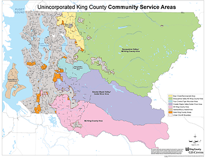
Community Service Areas
Where King County is your local government
Area descriptions
Rural area east of Woodinville, Redmond, and Sammamish. Includes the Redmond Ridge Urban Planned Development and the Sammamish Valley Agriculture Production District. Forested with several lakes, the Sammamish River Valley, and hills to the south and east.
Map
Bear Creek/Sammamish map (3.2 MB)
Rural area that surrounds the rural cities of Duvall, Carnation, Snoqualmie, North Bend, and Skykomish, plus the towns of Fall City and Snoqualmie Pass. Its eastern part is the Snoqualmie Valley, which has the Snoqualmie Valley Agriculture Production District and several rural cities and towns. Much of the land area is in the forested Cascade Range, with parts of the Mount Baker-Snoqualmie National Forest and the Alpine Lakes Wilderness Area.
Map
Rural area east of Renton and Newcastle and east and south of Issaquah. Contains the May Valley Basin and foothills of the Cascade Range, including Cougar Mountain Regional Wildland Park, Squak Mountain State Park, and Tiger Mountain State Forest.
Map
Four Creeks/Tiger Mountain map (1.7 MB)
Rural area east of Renton and Kent and north of Covington, Maple Valley, and Black Diamond. Extends east to the border with Kittitas County. Has low rolling hills and several lakes in the western part, while the eastern part is in the Cascade Range—including parts of the Forest Production District and part of the Mount Baker-Snoqualmie National Forest.
Map
Greater Maple Valley/Cedar River map (2.4 MB)
Rural area south of Maple Valley, Covington, and Black Diamond and east of Auburn. Surrounds Enumclaw. The northeastern part has the lower and middle Green River basins and includes the Middle Green River Valley Agriculture Production Districts and Hanging Gardens, Kanaskat-Palmer, Nolte, and Flaming Geyser state parks. To the south and slightly east of the river basins is the Enumclaw Plateau. The land further to the east is forested and includes part of the Mount Baker-Snoqualmie National Forest.
Map
Southeast King County map (2.1 MB)
Unincorporated urban areas, including East Federal Way, North Highline, West Hill, Fairwood, and East Renton. These areas have the potential to be annexed to neighboring cities.
Maps
- West King County – north and east areas (1.7 MB)
- West King County – south central areas (1.5 MB)
- West King County – south areas (1.4 MB)
Rural area covering all of Vashon-Maury Island. Accessible only by water, the island has a rich mix of parks, beaches, and local craft and agricultural production.
Map
Map (66 KB)
The Community Service Areas program informs, involves, and empowers people and communities in unincorporated King County by…
- Expanding outreach and communication to a wide range of community organizations.
- Identifying a county employee who will serve as a liaison, public advocate, and information clearinghouse for each Community Service Area.
- Providing resources to communities in unincorporated areas through the Community Service Area Grant Program, which offers matching funds for community-led projects through a yearly grant application process for community organizations.
2024 Community Engagement Grants
King County’s Alan M. Painter Grant Program funds community projects that allow unincorporated area residents to participate in, and be more connected to, their communities and King County. Funded projects must demonstrate how they are accessible to all residents regardless of race, income, or language spoken. Please note: These funds may not be used for political activities.
A total of $90,000 will be reimbursed for projects in 2024, in individual grants of less than $5,000 per project. Funding for projects will begin in March 2024.
A total of $90,000 will be reimbursed for projects in 2024, in individual grants of less than $5,000 per project. Note: the application period for 2024 grants is now closed.
- Information —details and how to apply (for information only)
Grant recipients in previous years
Subvenciones para Participación Comunitaria para 2024
El Programa de Subvenciones Alan M. Painter financia proyectos comunitarios que permiten a los residentes del área no incorporada participar y estar más conectados en sus comunidades y al King County. Los proyectos financiados deben demostrar de qué manera las actividades serán accesibles para todos los residentes, sin importar su raza, sus ingresos o el idioma que hablen. Tenga en cuenta: estos fondos no pueden usarse para actividades políticas.
Se reembolsará un total de $90,000 a los proyectos en 2024. Cada proyecto recibirá menos de $5,000. Las solicitudes de subvenciones para 2024 ya están cerradas.
Beneficiarios de subvenciones en 2024 (en inglés)
Services
Visit these pages for information about King County services, work plans, initiatives, and projects in your community.
TOPICS: Emergency Management | Flooding | Habitat | Information Technology | Newsletter | Parks | Police and Fire | Road Services | Stormwater | Transit | Waste Disposal | Water and Land
Emergency Management
- ALERT King County – sign up for emergency alerts
- How to prepare
- Trusted Partner Network – volunteers link communities that speak languages other than English with King County’s emergency alert system
Flooding
- Flooding preparation, support, maps – Natural Resources & Parks
- River and floodplain management – Natural Resources & Parks
Habitat
- Habitat restoration – Natural Resources & Parks
Information Technology
Newsletter
- Unincorporated Area News (monthly electronic newsletter about King County services and opportunities in unincorporated areas)
Parks
- King County Parks – Natural Resources & Parks
Police and Fire
- Texting 9-1-1 – what you should know
- Alternate phone numbers for local police and fire when 9-1-1 service is down
- 9-1-1 safety for kids
Road Services
- King County Road Services – Local Services
- 24/7 Road Helpline – Local Services
- Closed and restricted roads – Local Services
- Projects, plans, reports, and standards – Local Services
Stormwater
- Stormwater services – Natural Resources & Parks
Transit
- Metro home page
- Tools for trip planning
- Travel options:
Accessible Services
Bus service
Community Van
Metro Flex
Rail travel
RapidRide
Vanpool and Vanshare
Water Taxi - Service advisories
- Winter guide
- Programs and projects
Waste disposal
- Garbage, recycling, and compost services – Natural Resources & Parks
- Hazardous waste disposal – Natural Resources & Parks
- Wastewater treatment – Natural Resources & Parks
Water and land
- Water and land resources services – Natural Resources & Parks
- Water and land use, rural and regional services – Natural Resources & Parks
Map
View/download (4.3 MB)
Contacts
- Marissa Alegria
Community Liaison
Send Marissa an email - Bong Sto. Domingo
Community Liaison
Send Bong an email