
 Translate
Flooding in the Snoqualmie-South Fork Skykomish Watershed
About flooding in the Snoqualmie-Skykomish watershed
The Snoqualmie-Skykomish watershed is in northeast King County. The watershed is the land from which rainfall and snowmelt all flow towards the Snoqualmie River and the Skykomish River. The Snoqualmie and Skykomish rivers begin in the steep Cascade Mountains. Rivers within the watershed generally flow west and north across King County and into Snohomish County, where they join the Snohomish River that empties into Port Gardiner north of the City of Everett.
The Snoqualmie watershed is often divided into the upper and lower Snoqualmie. These two sections are split by Snoqualmie Falls, a 262-foot high waterfall.
Above the falls, the South and Middle Fork Snoqualmie River flow on either side of the City of North Bend and adjacent unincorporated communities. After the North, Middle and South Forks join, the Snoqualmie River flows west through the City of Snoqualmie and over Snoqualmie Falls.
At the base of the falls, the watershed is relatively steep, but it soon becomes a broad, flat valley. The lower Snoqualmie River meanders in wide loops flowing north by the community of Fall City and the cities of Carnation and Duvall. There is a robust farming community in the lower Snoqualmie valley.
The Tolt and Raging rivers join the Snoqualmie River below the falls. Both rivers carry sediment to the Snoqualmie valley. Sediment can change how the Snoqualmie River moves across its floodplain in the valley and its flood flows.
The South Fork Skykomish River is located along King County’s northern border. The river flows west through the Town of Skykomish and the community of Baring before entering Snohomish County.
Flood risks in the watershed
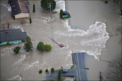
- The rivers in the Snoqualmie-Skykomish watershed are the most flood-prone in King County. This is due to historical townsites being located along the rivers and that the flood structures, built largely in the 1960s, do not provide complete levels of flood protection to nearby communities.
- Significant rainfall is the primary cause of major flooding throughout the watershed. Slow-moving floodwater is typical in the lower Snoqualmie valley, but faster flows are possible.
- Slow-moving floodwater can still be dangerous for people, and can cover roads, damage buildings, and cut off utilities.
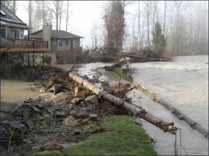
- The steep channels of the Tolt, Raging, and South Fork Skykomish rivers as well as three forks of the Snoqualmie River above Snoqualmie Falls are subject to erosion. This can cause channel migration that can threaten structures near the active channel.
- The cities of North Bend and Snoqualmie both experience regular flooding. Deep floodwaters can inundate low-lying residential and commercial areas, close roads, and isolate communities.
- Flooding from the South Fork Skykomish can cover roads and isolate communities.
Flood infrastructure in the watershed
There are more than 200 levees and revetments maintained by King County in the Snoqualmie-Skykomish watershed. A levee is a raised structure built along a riverbank to contain, control, or divert the flow of water and protect the land along the river from temporary flooding. A revetment is a structure built along a riverbank to reduce erosion risks.
The segments of the Tolt River near Carnation and the South Fork Snoqualmie River near North Bend have nearly continuous levees and revetments. However, these structures provide inconsistent levels of flood risk reduction and floodwater may overtop levees in certain locations.
The City of Seattle owns and operates the Tolt Dam, located upstream from Carnation. The dam and reservoir provide drinking water and generate power. Any flood risk reduction provided by the dam is incidental.
Snoqualmie Falls has a unique and important influence on flooding in the Snoqualmie watershed. Two large flood risk reduction projects, constructed between 2004 and 2012 by the U.S. Army Corps of Engineers and Puget Sound Energy, altered the opening where the river flows over the falls. The projects resulted in a slightly higher peak 100-year water level downstream of the falls and lowered the peak 100-year water level upstream in the City of Snoqualmie. The peak 100-year water level is the height that water is expected to rise during a flood event that has a 1% chance of happening in any given year.
King County completed a Snoqualmie River Hydraulic Study evaluating these projects in 2016. King County also completed a companion Snoqualmie River Hydrologic Study in 2018 that investigated issues related to river gages, historical trends, basin hydrology, and flood events.
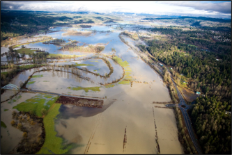
The importance of healthy floodplains
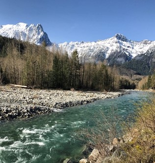
South Fork Skykomish River, near Index
When rivers are connected to their floodplains, there is more space to store and slow down floodwater. Historic changes to the landscape have resulted in many areas where rivers and their tributaries in the Snoqualmie-Skykomish watershed are disconnected. King County has several projects in various stages of planning to reconnect rivers in this watershed to their floodplains. These projects also help to improve fish and wildlife habitat.
The Tolt, Raging, South Fork Skykomish and Snoqualmie river below Snoqualmie Falls, are highly valuable for salmon habitat and production. Other fish species thrive in the Upper Snoqualmie watershed.
We consider potential impacts to fish, wildlife and people when designing flood risk reduction projects.
Want to learn more about the future of your watershed?
Flooding in the Snoqualmie-Skykomish Watershed is common and expected to increase due to climate change. The University of Washington Climate Impacts Group estimates that by the 2080s greater rainfall and snowmelt will cause the Snoqualmie River to have 15-25% more water October through March. Similarly, the South Fork Skykomish will have 17-33% more water during the same timeframe. The increased amount of water is likely to cause bigger and more frequent floods.
Typical approaches to reduce flood risks in this watershed include:
- Maintaining and repairing existing levees and revetments.
- Buying flood and erosion prone properties from willing sellers. This permanently removes people and homes from harm’s way.
- Elevate eligible homes and structures to raise the living floor above the base flood elevation. This reduces future flood damage.
- Build levee setback projects to reconnect floodplains allowing more space for flood water to move and be stored naturally.
Capital Investment Strategies have been developed for the Tolt River and South Fork and Middle Fork Snoqualmie Rivers. These will be part of a reprioritization process in 2023 and 2024 at the direction of the King County Flood Control District. Projects will be reprioritized to ways to achieve multi-benefits using an integrated floodplain management approach. The process will have a focus on equity, social justice, and environmental justice.
The Tolt River Corridor Planning and Capital Investment Strategy
South Fork Snoqualmie River Corridor Planning and Capital Investment Strategy
Middle Fork Snoqualmie River Corridor Planning and Capital Investment Strategy
Resources
King County flood alerts
Sign up to receive flood alerts for the South Fork Skykomish, Snoqualmie, Tolt, or Raging rivers
Sign up for Tolt Dam Early Warning System Alerts
King County flood programs
Learn about King County’s Flood Buyout Program
Learn about King County’s Home Elevation Program
Check your river gage data
A river gage station is a location where hydrologists, or people who study the flow of water, gather information such as the height and depth of a river and the speed of the water flow.
Additional resources
Learn how to prepare for a flood
Free sandbag materials are available in Carnation, Fall City, North Bend, Skykomish, and Snoqualmie
Learn about common road closures in lower Snoqualmie Valley.
Projects and studies
Current projects
Lower Snoqualmie Basin
- Dutchman Road Revetment Repair project (located near the City of Duvall)
- Lower Frew Levee Setback project (located near the City of Carnation)
- Tolt River Road Northeast Elevation at San Souci project (located near the City of Carnation)
- Fall City Floodplain Restoration project (located near Fall City)
Upper Snoqualmie Basin
- Circle River Ranch Flood Risk Reduction project (located near the City of North Bend)
- Mason Thorson Ells Levee Rehabilitation project (located near the City of North Bend)
Multiple locations
- Levee Breach Analysis Mapping and Risk Assessment (Raging, Tolt, South Fork Snoqualmie and South Fork Skykomish rivers)
Key reports, studies, surveys
Snoqualmie River Hydrologic Study: Evaluation of Flooding Trends and Current Conditions 2018
Tolt River Channel Migration Zone Map
Raging River Channel Migration Zone Map
South Fork Skykomish River Channel Migration Zone Map
Recently completed projects
- Sinnema Quaale Revetment Repair (located between Carnation and Duvall)
- This project repaired a riverbank on the lower Snoqualmie River to protect SR 203, the Snoqualmie Trail, and regional fiber optic lines and improve aquatic edge habitat.
- Tolt Pipeline Protection Revetment Reconstruction (located between Carnation and Duvall)
- Repaired a riverbank on the lower Snoqualmie River to protect a water supply pipeline to the Seattle area, improve flood drainage to local roadways and nearby agricultural lands, and improve flood refuge and tributary access for threatened salmonids.
- Southeast 19th Way Revetment Repair (downstream of Fall City)
- Repaired a riverbank on the lower Snoqualmie River to reduce erosion risks to a sole access King County road.
- Reinig Road Revetment Repair (located northeast of the City of Snoqualmie)
- Repaired a riverbank on upper Snoqualmie River to protect Reinig Road from erosion.
- Shake Mill Left Bank Revetment Reconstruction (a bank protection project on the North Fork Snoqualmie River to reduce erosion risks to 428th Ave SE and the North Fork Bridge)
- Miller River Road Revetment Repair (a bank protection project on the Miller River Road to maintain regionally important recreational access)
- Upper Carlson Floodplain Restoration Project (a floodplain restoration project on the lower Snoqualmie River near Fall City to restore critical habitat for threatened Chinook Salmon and Steelhead and replace needed flood and erosion protection in a location and way that allows for restoring and sustaining high quality habitat in the river and floodplain)